PROJECT 1947
 A Study of the Lockheed Sightings
an unusual aerial phenomenon in the Santa Barbara Channel area
seen by multiple technically-expert observers in the air and on
the ground
during a Lockheed WV-2 flight test, Dec 16, 1953
Martin Shough1
1 UK Research Associate, National Aviation Reporting Centre on Anomalous Phenomena (NARCAP). © Martin Shough, July 2014.
Author
email: parcellular@btinternet.com.
Thanks to Mary Castner for
information and discussion relating to the Johnsons' Agoura
property, to Don Ledger for insight into certain WV-2 flight
characteristics, and to Brad Sparks for useful discussions
concerning the Project Blue Book documents and background, and many
other aspects of the case. Particular thanks to the late Joel
Carpenter for locating obscure radiosonde data.
A Study of the Lockheed Sightings
an unusual aerial phenomenon in the Santa Barbara Channel area
seen by multiple technically-expert observers in the air and on
the ground
during a Lockheed WV-2 flight test, Dec 16, 1953
Martin Shough2
1. Summary and background
At 16:29 PST on Dec.16, 1953, shortly before sunset, a 4-engine
Lockheed WV-2 (#LAC 4301), took off from the Lockheed Air Terminal
(LAT) at Burbank, California3, for a flight test. The WV-2 was a
Lockheed R7V-1 Super Constellation airframe adapted as a Navy radar
early warning aircraft by the addition of large dorsal and ventral
blisters or radomes containing radar antennas. On board were five
of the Lockheed Aircraft Corporation's top technical employees:
 Roy E. Wimmer, Engineering Test Pilot
Rudy L. Thoren, Chief Flight Test Engineer and Co-Pilot
Philip A. Colman, Chief Aerodynamics Engineer
Charles Grugan, Flight Engineer
Joseph F. Ware, Jr., Flight Test Section Supervisor
The flight plan was to take the WV-2 out over the ocean to 10,000ft,
perform some test manoeuvres, then continue climbing to the
aircraft's near-maximum height of 20,000ft for further tests before
returning to LAT.
During the climb to 20,000 ft, at approximately 17:00 PST, an
object was seen in sharp-edged black silhouette against the
post-sunset sky, appearing to be stationary in the air over the sea,
at their own height or a little higher, judged to be many miles
away, between Pt Mugu and the Santa Barbara Channel islands. It had
the shape of a discoidal or flying-wing-shaped object in
approximate profile. Thoren at the controls turned the WV-2 a
little and flew towards the object. They did not appear to close
the distance noticeably for about five minutes, then the silhouette
began to rapidly shrink, maintaining its sharp-edged shape, until
it vanished completely in about one minute. All the observers felt
that it was a solid object which dwindled because of rapid motion
away from them.
Simultaneously (17:00PST ± 2 min) two independent witnesses were
observing what was subsequently agreed by all parties to be the
same object from a ranch house on a hillside at Agoura, California.
These observers were:
 Clarence "Kelly" Johnson, Chief Engineer, Lockheed Aircraft Corporation
Althea Louise Johnson, wife of Clarence Johnson, former Lockheed
accounts employee
The sharp-edged, "intense black" silhouette was observed above
mountains in the west for approximately 5 minutes, with the naked
eye and with 8x binoculars. It hung apparently stationary against
the post-sunset sky at a bearing of ~255º True until it dwindled
and disappeared in 90 seconds on a "long shallow climb".
On the following day when Thoren mentioned the WV-2 sighting in
Johnson's office, Johnson leapt

2 UK Research Associate, National Aviation Reporting Centre on Anomalous
Phenomena (NARCAP). Author email: parcellular@btinternet.com
in and "dumbfounded" Thoren by describing his own "saucer". The two
discovered that they appeared to have observed the same thing
simultaneously from widely separated positions such that their
lines of sight differed by tens of degrees. Both groups of
observers were strongly impressed, and all believed that they had
made triangulated observations, from the ends of a long baseline,
on a well-defined, solid object capable of rapid flight,
specifically not a cloud of any type.
Five eyewitness reports4 were collected together under special
cover by Johnson, together with drawings and a map, and forwarded
discreetly on Jan 20 1954 via Lt. General Putt to Project Blue Book
at the Air Technical Intelligence Center, Wright Patterson AFB,
Dayton, Ohio for "such scientific purposes as your group may be
concerned with" (see Appendix).
At this point there is no further evidence of any investigative or
analytical activity. Essentially the reports were merely filed,
exactly as they had been submitted, except that the single copy of
the sighting map, drawn by Joseph Ware, was at some point lost and
is today missing from the file. The Project 10073 Record Card is
the only extant official document generated by Blue Book. Under
BRIEF SUMMARY AND ANALYSIS we read: "First appeared as black
stationary cloud, then rapid movement in long shallow climb" And
under CONCLUSION we read: "OTHER - CLOUD lenticular cloud"
2. Method
It is of first importance to establish the observers' locations and
lines of sight in order to reconstruct the sighting geometry. For
both groups of observers there is some approximation involved.
In the case of the observers on the ground, the Johnsons' Lindero
Ranch and its ranch house no longer exist in the form known in 1953,
and precise map references were not stated. Nevertheless the
location can be inferred with acceptable accuracy from the
following evidence: topography, Kelly Johnson's biography,
historical land grant maps, investigations and interviews with
Agoura neighbours conducted by previous researchers,5 and sighting
bearings and landmarks noted in the witness statement, refined by
inspection of likely ground sites and their lines of sight (LOS) in
Google Earth. It will be argued that the constraints coming from
all these parameters dictate the sighting position, LOS bearing and
LOS elevation to a sufficiently good approximation that the angular
uncertainties are wholly negligible in relation to all physical and
geometrical factors.
In the case of the observers on board the WV-2, the location is
less certain since they were obviously mobile in three dimensions.
The map drawn by Ware was mislaid by the Air Force. The detailed
Flight Record was apparently never sought from Lockheed. No ground
radar was involved which might have helped us to establish a ground
track, and this was of course an age long before electronic
navigational aids such as satellite GPS. The task therefore is to
reconstruct, by dead-reckoning, using known performance parameters
of the Lockheed WV-2 and known winds aloft, a likely approximate
course consistent with the limited number of times, positions,
speeds, headings, navigational marks and bearings recorded in the
witness statements. It will be argued that the constraints coming
from these recorded data-points dictate the sighting position(s)
and LOS bearing to a sufficiently good approximation that the
angular uncertainty is small in relation to the significant angle
subtended by the baseline between the WV-2 and the observers on the
ground.
We then investigate the apparent triangulated position in space,
apparent radial and/or angular motions and angular size changes of
the phenomenon in the light of various meteorological and
atmospheric-optical considerations, to discover what constraints
emerge on a possible physical theory to explain the observations.
4 Accounts were either not sought or were not available from Althea
Johnson and Charles Grugan.
5 The author is especially indebted to Mary Castner of CUFOS for
sharing information collected by her.
3. WV-2 course & sighting location
We have a number of knowns: The airfield location is known. The
take-off and approximate landing times are known. The general
ascent profile and some course headings and turn points are
approximately known. The altitude, airspeed and headings of the
WV-2 during the observation are approximately known. The time of
the observation is known (to within a minute or two), and both the
compass bearing of the object from the WV-2, and its apparent
location relative to named landmarks, are approximately known.
But there are several significant unknowns: What geographical point
is signified by a phrase like "somewhere in the vicinity of Long
Beach or Santa Ana" (geographical point of turn from a SE onto a W
heading), or "over the Catalina Channel area between Avalon and
Palos Verdes hills" (initial sighting point)? And to investigate
these questions by reconstructing the course flown invites other
questions: On what initial heading did they "climb out towards the
ocean"? What was the nature and duration of the tests conducted on
the climb to 10,000ft? What was the heading of the "level run" they
then made for "a few minutes"? Where was the subsequent turn onto a
SE climbing heading commenced? What were the radii of these turns?
And so forth.
An attempt was made to find answers to these questions by
interpolating between the various known parameters using published
specification figures on the rates of climb and associated
airspeeds at different altitudes of the WV-2 and related Super
Constellation variants, in order to reconstruct a best-fit flight
path. (In what follows the reader should refer to Figure 2.)
1st leg: point 1 to point 2 6
At the WV-2's usually-specified climb rate of 960 fpm7 an initial
climb of 10,000 ft would have taken approximately 10½ minutes, but
for several reasons this is not realistic. Firstly the runway
altitude of LAT is 778 ft MSL (237m), thus a climb to 10,000ft MSL
is only 9222 ft. On the other hand 960 fpm would be a maximum rate
of climb (RoC) at sea level. Even keeping all other factors
constant the rate of climb reduces in proportion to decreasing air
pressure or increasing altitude. Additionally, whilst maximum climb
would be used off the end of the runway to put distance below the
aircraft for safety, it would then become necessary to reduce the
angle of attack, trading RoC for forward airspeed in order to
control rising heat and manifold pressure in the air-cooled Wright
turboprop engines.8 How do these factors affect the time to climb?
Detailed climb performance figures for the reconfigured WV-2 are
not available, but figures for the Navy R7V-1 Super Constellation
transport version (without radomes) are available in a 1952 Navy
Standard Aircraft Characteristics publication. These figures (Table
1) and graphs (Fig.1) offer a guide which can help us calibrate the
information available in the sighting report.
Working first from the Flight Record data quoted by co-pilot Rudy
Thoren9 we find that the WV-2 levelled off at its final test
altitude of 20,000ft at 17:10 PST, indicating an overall average
rate of
6 The true initial heading is not recorded, and we should think of the Fig.2 track as representing a rough equivalence class
of similar paths heading "out towards the ocean", general
constraints on which are explained in the text.
But the most fuel-and time-efficient climb from LAT's Runway 26 (today 256º Mag,
271ºTrue) would be to continue, insofar as is consistent with the
flight plan, directly into the winds aloft which (see below)
probably averaged ~SW through the first leg. A possibly equally
fuel-efficient climb would be (e.g.) on a SSW (True) heading
towards Catalina, then looping back N to position for the SE run
from Point 3 towards Long Beach. But there is no specific evidence
favouring this interpretation, and the conclusions of this section
would not be altered by more than a few percent, an uncertainty
which can be absorbed negligibly into the overall uncertainty in
the reconstruction.
8 Email from Don Ledger, 26.02.2011
9 Thoren statement 17.12.1953
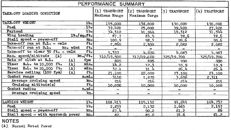
Table 1. R7V-1 Lockheed Super Constellation performance figures
from Standard Aircraft Characteristics NAVAER 1335A (REV.1-49) 1
July 1952
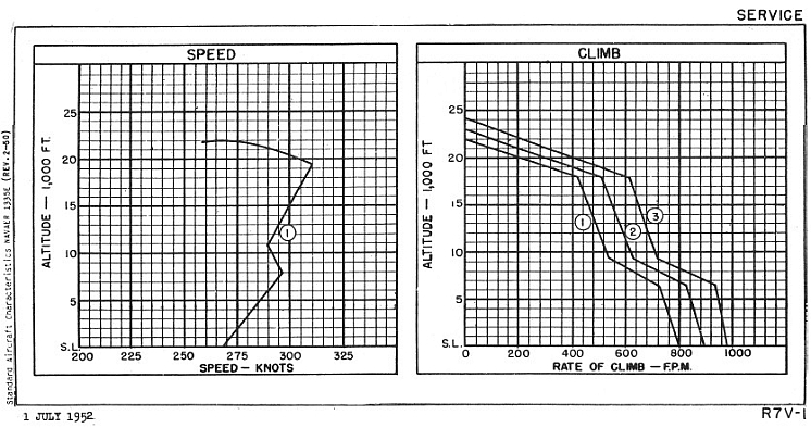
Fig.1 R7V-1 Lockheed Super Constellation speed and climb graphs from
Standard Aircraft Characteristics NAVAER 1335A (REV.1-49) 1 July
1952
climb of 487 fpm. Obviously the average rate of climb during the
first 10,000 ft is more than this. We can refine our guess by
noting that the average rate during climb to the sighting altitude
(16- 17,000 ft at ~17:00 PST) was about 530 fpm, whilst at the
sighting altitude it was by then not much more than about 300 fpm
(>10 min from that level to 20,000 ft). So we know that the average
during the initial 10,000 ft of climb was somewhat more than 530
fpm, and in a first approximation we should assume it was somewhat
less than the specification maximum of 960 fpm (but see below). If
we were to again crudely average these two figures we would get 745
fpm, bearing in mind that the averaging proceedure tends to
underestimate because the RoC curve is non-linear.
Turning then to the Navy specifications for the R7V-1 Super
Constellation we find that the RoC at sea level is 805 to 990 fpm
depending on loading condition, reducing to ~520 to 710 fpm at
10,000 ft, and time to climb from sea level to 10,000 ft is between
10.9 and 14.2 min. So we have a mean time of 12.5 min at a mean RoC
of about 800 fpm with a mean airspeed of 285 kt.10
If we were to transfer these figures to the WV-2 then, ignoring
winds, they equate to a flight distance of 68 stat mi. This is a
rather long distance to fit on the map, bearing in mind the time
available for the remainder of the climb and the need to position
the plane heading SE from near Point 3 to enable a right turn onto
a west heading near Point 4 off the Long Beach-Santa Ana area. A
lower airspeed/groundspeed would fit better. There are several
lines of argument tending in this direction:
- Clearly the large radomes must contribute to a difference
in performance between the R7V-1 and WV-2. One might guess that,
all else being equal, there could be comparable reductions in
airspeed and RoC of a few percent.11 But clearly not all else is
equal. The WV-2 specs on- line give a much lower maximum speed than
the R7V-1's ~317 kt (310-325kt at normal rated power, depending on
loading). The usual WV-2 max stated is 260kt. This is 25 kt lower
even than the mean speed in climb to 10,000ft of the R7V-1. On the
other hand, the RoC is scarcely any different. The operational
specification RoC for the WV-2 is generally given as 960 fpm
(sea-level), comparable therefore with the ~900 fpm (805-990 fpm)
sea-level RoC of the R7V-1. We are here comparing initial climb
rates, not averages; nevertheless a lower forward airspeed and a
similar or higher initial RoC clearly suggests that the WV-2's
angle of climb will be steeper than the R7V-1 and the projected
ground track proportionately shorter than 68 miles.
- It seems reasonable to assume that the mean airspeed in
climb to 10,000 ft might be approximately the same proportion of
maximum airspeed in both versions. This ratio for the R7V-1 is
285:317, or 1:1.114. If this ratio is transferrable then the mean
airspeed in climb to 10,000 ft of the WV-2 is about 234 kt. That
would reduce the distance flown in 12.5 min to ~49 n mi (56 st mi)
so let's say the projected ground track is about 55 st mi.
-
Note that we have used here an average time-to-climb figure
from the R7V-1 specs. If we use the shorter 10.9 min figure
appropriate for the lightest loading condition (smaller fuel load,
smaller payload, higher RoC of 990 fpm) which is arguably a better
comparison for the WV-2 in this case (short trip, light fuel load,
light payload - see below) then by the same calculation the
distance flown reduces to 42.5 n mi, or less than 50 st mi on the
ground.
As stated, the specification sea-level RoC of the WV-2 is 960 fpm.
This is about 3% less than the 990 fpm given for the R7V-1 in its
lightest take-off loading condition. But it is certainly possible
that WV-2 LAC4301 climbed faster than its specification figure. The
latter figure would also be for
10 Crude proportionality would suggest a small 7.8% correction
due to the fact that he climb from LAT begins at 778 ft, but this
is partially offset by the reducing average efficiency of lift and
RoC above this height. We ignore the residual few % as a negligible
factor relative to other uncertainties, which is conservative since
the tendency would be if anything to slightly shorten the ground
track.
11 Pilot, author and researcher
Don Ledger estimated perhaps 5% in both quantities (email to the author, 19.03.2011)
a typical operational mission loading, in terms of fuel and payload,
and the WV-2's long-duration radar picket flights of typically >18
hrs meant big tanks and a heavy fuel load. This WV-2 would have
been fuelled up only for the short test flight (~90 min;
unnecessary fuel would not be taken on, it is whenever possible
calculated so as not to land with unsafe quantities still in the
tanks) and even assuming the radar gear was fitted (this isn't
stated but perhaps we can assume it) it carried only a flight crew,
not the 20 or 30 personnel and gear needed to operate the radars in
mission conditions.
The empty operational weight of the WV-2 was 69,210 lb (31,387 kg)
and the max take-off weight was 143,000 lb (65,000 kg).12 This
ratio can be compared to the R7V-1, which weighed about 71- 72,000
lb empty and up to 145,000lb maximum. On average (depending on
configuration) about 33,000lb of the R7V-1's weight was a full fuel
load (25,000 to about 40,000lb). The WV-2's long mission time
required added tip tanks for a much larger capacity of 8,768
gallons or more than 61,000 lbs of fuel. With fuel being a much
greater proportion of its slightly smaller maximum empty and
take-off weights, the relative performance savings of having only a
light fuel load would be proportionately higher for the WV-2. And
the fuel-load saving for a 90 min flight would be significant. Say
120 min of fuel burned at 4760 lb/hr13 plus a ~2500 lb designed
landing fuel-weight (to use the R7V-1 spec) equals ~12,000lb, or
36% of the average 33,000lb full load of an R7V-1 and only 20% of
the full load of an operational WV-2, an overall weight saving of
49,000 lb or 34%.
How does the light load factor in against the increased drag from
the radomes?
- We might be safe in assuming that a (say) -5% drag
inefficiency in climb is at least cancelled out by a +34% weight
efficiency, at least preserving the R7V-1's mean time-to-climb of
12.5 min at a mean RoC of 800 fpm. Indeed, could the very
lightly-loaded LAC 4301 in this test configuration have
significantly exceeded the WV-2's specified 960 fpm initial RoC,
achieving perhaps ~1000 fpm over the climb to 10,000 ft and
reaching this level in <l0 min at say 240kt mean airspeed? It seems
quite possible. If so, then we could get the distance down to about
45 st mi. That would be a more comfortable fit.
Finally, the heading during the climb "out towards the ocean" to
10,000 ft must have had a significant western vector component, and
may well have been directly into the winds aloft. Indeed, this is
likely to have been the deliberate flight plan, for reduced
time-to-climb and maximum fuel economy. The Weather Service daily
map shows wind at ~10,000 ft (700mbar pressure surface, Fig. 4)
generally from the West.
Kelly Johnson's visual observation of cloud motion from Agoura was
"onshore, in a direction of travel opposite to that of the object",
i.e. reciprocal to a heading of ~250º (WSW or roughly W). At the
time of the 2330 PST surface weather observations a few hours later,
the generally clear skies over the S California area mean that the
daily maps (Fig.3) show few "direction of cloud movement" arrows
and none for coastal sites near the sighting area. But those shown
indicate generally W-E motion consistent with Johnson's observation.
Beyond the Bight area, 75 mi NW at Santa Maria, the winds at 1900
PST were SE all the way up to 6500 ft, but by 2330 PST had swung at
the surface to WNW, 5kt. There is a 10kt NE surface wind at Los
Angeles which may be a local drainage wind or mountain breeze from
the mountains east of the LA basin, a katabatic cold flow usually
limited to the first few hundred feet (the mechanism responsible
for the area's famous Santa Ana winds). A similar surface flow is
also seen on the hourly observations at Point Mugu (Fig.18) where
the wind at the sighting time was ESE, 7kt.
13 "These engines would be burning over (a guess knowing the fuel/hour rate of 1.7 times the hp of a C-46 (~100gph)) about 170 gal/hr per engine (680 GPH for all 4 engines) times 7 pounds per gallon of 100/130 octane fuel = 4760 pounds per hour. A two hour flight would have used nearly 5 tons of fuel." Email from Don Ledger, 26.02.2011
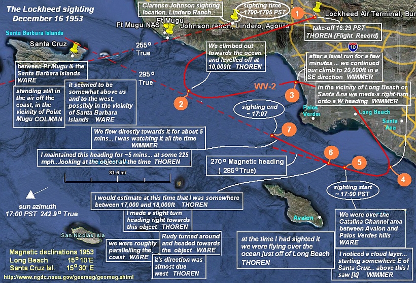
Fig.2. Reconstruction of possible WV-2 flight path, sighting positions and bearings
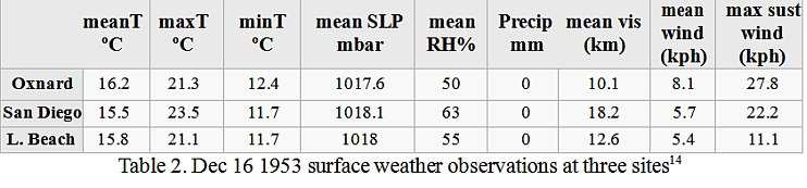
Mean surface winds and other observations recorded at three further
stations are shown in Tables 2 and 3. Sustained speeds of up to
15kt occur at Oxnard but direction is not recorded. Surface wind at
LA Int. Airport (Fig. 20) was W/WSW 4mph (3.5kt) at 1700 PST
falling calm by 1725 PST. The daily chart shows winds aloft at
700mbar (~10,000ft) ~ Force 4 (11-15 kt) from the SW (Fig 4)
.
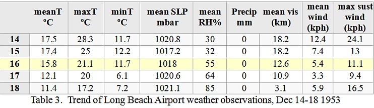
More significant are three radiosonde profiles, from Long Beach and Santa Maria timed at 1700 PST (Figs.17&18), and from San Nicholas Island timed at 1500 and 2200PST (Fig.19).15 The lowest wind readings combined with the surface obs in Fig.3 & Tab.4 confirm a variable breeze circulation on the coast. In particular we see that the 10 kt NE surface flow at Long Beach on the 2330 PST chart was much weaker (2 kt) measured at 1900 PST and at 20m height, consistent with this being a local night drainage wind developing after sunset, and we can also see the upper wind direction rotating through the first few hundred meters, becoming SSW and then due W at about 13,000ft. As it turns to the west above the first km (~3000 ft) it strengthens, averaging ~13 kt through the next 10,000ft. The Santa Maria profile is probably less relevant, being well north and west of the flight area, but it also shows wind direction rotating to the W at about the same height, but weaker and above a deeper layer of SSE flow (which can be seen also on the San Nicholas profile 60 mi W of Catalina). Diurnal variation of windspeed on the California coast has been studied. In one large study winds at almost all stations showed speeds in the generally westerly airflow peaking at about 1600 PST, reducing thereafter to a minimum around 2400 PST.16 This pattern holds also for the Channel Islands ocean area as a whole17 and for the Santa Barbara Channel in particular.18
These limited data suggest that winds aloft through the first 10,000 ft at 1700 PST may have averaged perhaps 10 kt or more from the SW, further clipping the WV-2 track by several percent.
These limited data suggest that winds aloft through the first 10,000 ft at 1700 PST may have averaged perhaps 10 kt or more from the SW, further clipping the WV-2 track by several percent.
-
So we can say that a round figure of 40 st mi is a reasonable guess, with the WV-2 arriving near Point 2 in Fig.2 at about 16:39 PST.
15 I am indebted to members of the James Randi Educational Forum who located and posted the raw data which I have graphed in Figs. 17 & 18.
See:
http://forums.randi.org/showthread.php?postid=7988371#post7988371 (Thanks also to Wim Van Utrecht for the lead.) Figs.19 & 20: images courtesy of Joel Carpenter, email to author Feb 20, 2013.
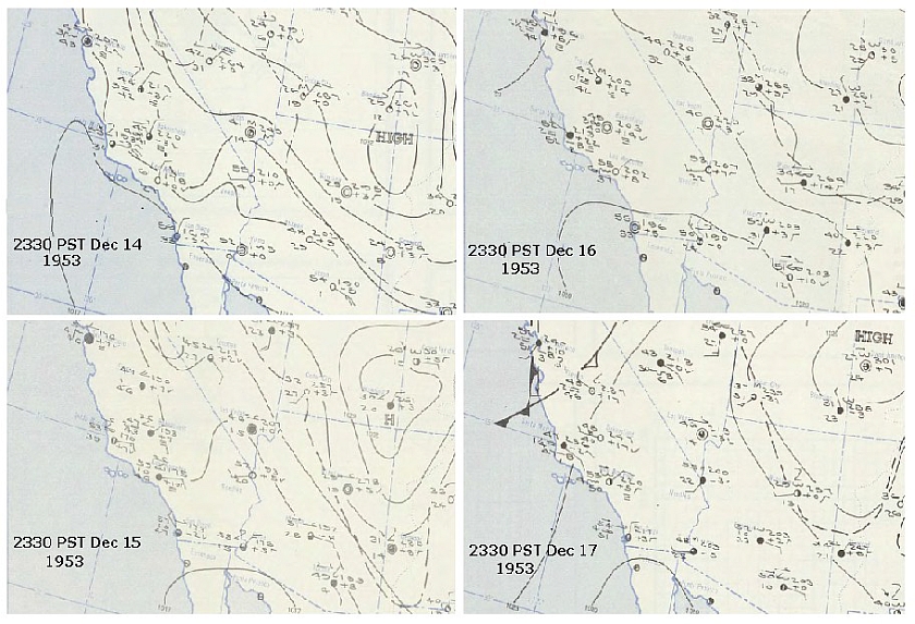
Fig. 3 Surface weather observations for 0130 EST Dec 15-18 (2330 PST Dec 14-17) 1953
http://docs.lib.noaa.gov/rescue/dwm/data_rescue_daily_weather_maps.html
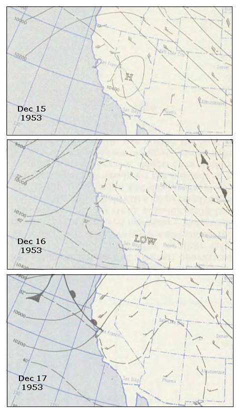
Fig.4 Heights (ft), temperatures (ºF) and winds at 700mbar pressure surface, observations
between 1000 - 1330 EST (0800 - 1130 PST) Dec 15 - 17 1953
http://docs.lib.noaa.gov/rescue/dwm/data_rescue_daily_weather_maps.html
2nd leg: point 2 to point 3
After climbing out over the ocean the WV-2 "levelled off for a short test" (Thoren) and "made a level run for a few minutes" (Wimmer) at 10,000ft. In order to position the WV-2 for its continued 3rd leg climb towards 20,000 ft ("in a southeasterly direction" with a further "right turn onto a west heading" [Wimmer] "in the vicinity of Long beach or Santa Ana" [Wimmer] to a sighting point "over the Catalina Channel area between Avalon and Palos Verdes" [Ware] before 17:00 PST), this 2nd leg needs to take the WV-2 back towards the coast near Point 3 somewhere south of Santa Monica. The length and duration of this leg depend on the WV-2 airspeed and the windspeed. Taking the airspeed on this level run of about 30 st mi to be the WV-2's specification cruise airspeed of 217kt (250mph) plus the advantage of (say) a 15kt westerly (True) tail wind, then the plane arrives at Point 3 at 16:39 + ~7 min = 16:46 PST
3rd leg: point 3 to point 4
From 10,000 ft at Point 3, the climb to ~15,000ft near Point 4 at the start of a right turn onto a W heading at an average RoC (guesstimating proportionally from the slopes of the curves in Fig.1) of about 600 fpm takes the WV-2 some 8 or 9 min. At 250 mph airspeed this corresponds to a distance of 37.5 st mi or, allowing for a small vector component of tail wind, say approximately 40 mi on the ground, taking the WV-2 to somewhere near Point 4 at ~ 16:55 PST.
4th leg: point 4 to point 5
At some position near Point 4 off the coast SW of Long Beach and Santa Ana the climbing WV-2 begins a turn of unknown radius from its SE heading onto a W (magnetic) heading, towards the initial sighting point, Point 5. The altitude at the sighting point is about 16,000 ft (Colman) or 16- 17,000ft (Thoren). So a turning climb from Point 4 of 1000-1500 ft at perhaps 400 fpm takes 3 or 4 min, which at a lower ground speed in turn of (say) 220mph takes the WV-2 a distance of about 14 mi, bringing it to the sighting point "just a little before 5 o'clock" (Thoren), say 16:58, or 17:00 PST ("about 5 o'clock" - Colman;Ware)
.
5th leg: point 5 to point 6
From the first sighting at Point 5 the WV-2 continues briefly on a due W (Mag) heading climbing a further 500 - 1000 ft still at ~400 fpm in about 2 min until reaching the point of a right turn at Point 6 onto the exact bearing of the object, which appeared to be located "off Pt Mugu . . . between Pt Mugu and the Santa Barbara islands" (Thoren),19 "in the vicinity of Pt Mugu" (Colman) or "in the vicinity of the Santa Barbara Islands" (Ware). The WV-2 altitude is then 17,000 - 18,000 ft (Thoren) reaching Point 6 at approximately 17:00 or 17:02 PST
6th leg: point 6 to point 7
At Point 6 Thoren makes a "slight" right turn (shown here arbitrarily as 10º) onto a heading directly towards the object, and the WV-2 heading is constant from this point. A time of "roughly 5 mins" (Thoren) or "about five minutes" (Wimmer) at 225 mph (Thoren) = 18.75 mi of travel taking them to Point 7 at 17:05 or 17:07 PST, at which time the object begins to dwindle and disappear. It may have taken "about one minute" (Wimmer) or "around a minute" (Thoren) to vanish completely, giving us a probable time for the end of the sighting between about 17:06 and 17:08, or ~17:07 PST.
19 By "Santa Barbara islands" Thoren, like Ware, clearly means the island chain bounding the Santa Barbara Channel,
not to be confused with Santa Barbara Island, which is an isolated small island about 45 miles south of Point Mugu.
In summary: No precisely timed flight record or incident map has been preserved, and the witness accounts do not lock down all parameters. It is therefore necessary to convince ourselves that we are properly understanding the situation being described and, in particular, correctly identifying and interpreting the positions, bearings and headings given. This exercise demonstrates that a best-fit reconstruction similar in essentials to the course shown in Fig.2, which fits all qualitative and quantitative details of the crew reports and is consistent with known or inferable WV-2 performance specs and winds aloft, does plausibly bring the WV-2 to the sighting position and altitude indicated in the sighting reports, at the reported time, yielding a visual bearing to the object of approximately 295º True. (The maximum uncertainty in the average bearing angle from the WV-2 is estimated to be no more than ± 10º, the likely uncertainty less than half this figure.)
4. Johnson sighting location
From Clarence Johnson's sighting report dated Dec 18 1953 (see Appendix):
On Wednesday, December 16th, 1953, my wife and I went out to our ranch, which is three miles west of Agoura, California, and one mile north of Ventura Blvd. We arrived there at about sundown, which is close to 4:45 PM PST. We went immediately to our ranch house, which is located on a hill facing southwest.
Kelly married Althea Louise Young (February 27, 1910 - December 21, 1990), who worked in Lockheed's accounting department, in 1937, and they built a house in Encino, Ca. The date they acquired the Agoura property is unknown, but this further information appears in Johnson's co- written autobiography:
About 20 miles west of our home in Encino was undeveloped ranch land, where Althea and I pastured our horses. Several years after building our home, we had the opportunity to buy the Lindero Ranch, 226 acres of rolling country with a stream bordering its west side. Lindero means line or boundary and was the north west corner of an original Spanish land grant. We built a small house on a mountain top with a view of the Pacific Ocean to the southwest and a range of mountains in the other direction.20
The author is grateful to researcher Mary Castner for sharing further information. Building on the above sources, Castner examined local newspaper records and also made inquiries of the Lindero housing association, through whom she located a former neighbour working for the association who had been acquainted with the Johnsons and had known the property. Castner developed the following information which she kindly shared with the author:
The ranch house was built of concrete block with an area of about 900 sq ft. Its large living room had six-foot high windows across about 30 ft of the front, facing southwest. It was sold by the Johnsons to a developer in 1962 when the building of the Colorado River aquaduct inflated local taxes tenfold. The developer built 746 homes, dug a lake near the Ventura Freeway and called the development Lake Lindero. Castner's sources were unable to be explicit about the exact location of the original ranch house, or if it was still in existence, only that it had been accessible by, or was close to the area of, the Reyes Adobe Road (named for the 1850 dwelling known as the Reyes Adobe, now an historical visitor site) in Agoura Hills district, that it continued in use for some time as a Boy Scout HQ, and that it was not believed that the original site had since been built over.21
There are several clues here which may help to narrow down the location. We begin by examining the land deal which settled the boundaries of the Lindero Ranch. Johnson wrote: "Lindero means line or boundary and [the ranch] was the north west corner of an original Spanish land grant".
20 Johnson, Clarence L. "Kelly", and Maggie Smith,
Kelly: More Than My Share of It All. Smithsonian Institution Press, 1985, p.37.
ISBN0-87474-564-0
21 Emails from Mary Castner to the author, 04.03.20011
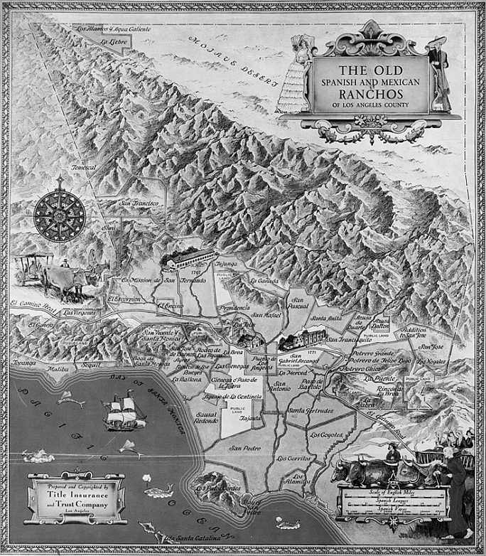
Fig.5. The Old Spanish and Mexican Ranchos of LA County.
Undated, but probably post-1882. Fairly accurate. Shows Las Virgenes abutting LA County boundary in the N and Rancho El Conejo in the W. See enlarged detail in Fig.6
The original concession was named El Rancho de Nuestra Senora La Reina de Las Virgenes and was granted by José Joaquín de Arrillaga to one Bartoleme Miguel Ortega in 1802. It was an area of 17,760 acres (72 km2). The approximate location and boundary of the rancho is shown on the undated Title Insurance and Trust Co. map22 in Fig.5, which confirms Johnson's claim and shows the NW corner of what became known as Las Virgenes (sometimes recorded as Las Virgines) nestling into a NW corner of the Los Angeles county boundary. A detail is shown in Fig. 7.
The old "royal road" to the west, or El Camino Real, that became the Ventura Boulevard or Ventura Highway (today US 101), ran through the middle of Las Virgenes. The corner of Las Virgenes that eventually became the Lindero Ranch lies to the north of the highway. A small detail from an 1833 map of the concession, drawn by surveyor Abel Stearn for a diseño in support of a land transfer petition (granted in 1837 in favour of Domingo Carrillo and Nemesio Dominguez, of Santa Barbara and Los Angeles respectively), is shown in Fig. 6. It is highly schematic (Stearn's own survey notes reportedly show a much more irregular boundary) but shows the north and west boundaries, the Camino Real road, and a distinctive stream formation roughly parallelling the west boundary or lindero.23
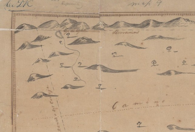
Fig. 6 Detail of schematic 1833 Stearn plan showing NW corner of Las Virgenes ranch.
Camino represents the highway. The dashed line marked Sierranias represents the north
"lindero" or boundary. The dashed line at left is the boundary with El Conejo ranch. (Note
the stream; compare Fig.10)
Ownership of Las Virgenes eventually passed to Maria Antonia Machado whose son, Jose Paulino Reyes, in about 1850 built the 'Reyes Adobe' house, known as the first house in Agoura Hills, after which is named the present-day Reyes Adobe Road.24 This road runs north past the adobe site towards the northwest corner of the concession which was to become Lindero Ranch.
23 Becker, Robert H., Diseños of California ranchos; maps of thirty-seven land grants; 1822-1846, from the records of the United States District Court, San Francisco, San Francisco Book Club, 1964. This is Becker's Map 35, L.A. County. It is map D1298 in the copy of the diseño held in District Court records; in the National Archives it is Expediente 54; in the State Archives, Expediente 54, and in the Board of Land Commissioners, no. 508.
See:
http://www.sbcordero.net/RanchoLasVirgenes.html
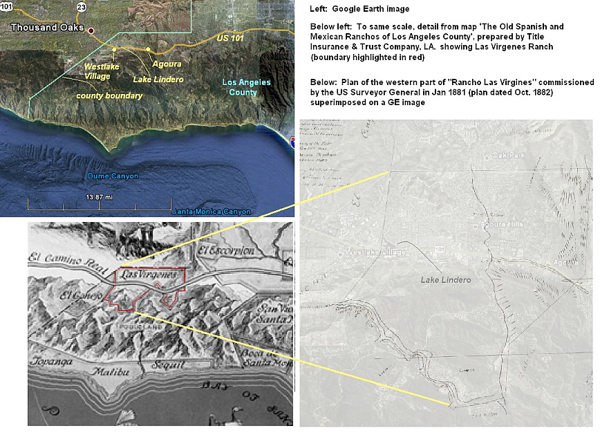
Fig. 7. (see also Figs. 8 & 9)
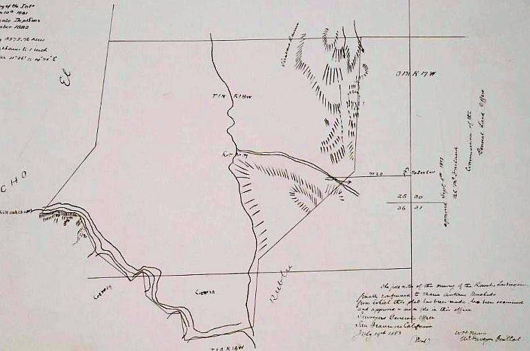
Fig 8. Newly-surveyed 1882 plan of west side of "Ranch Las Virgines"
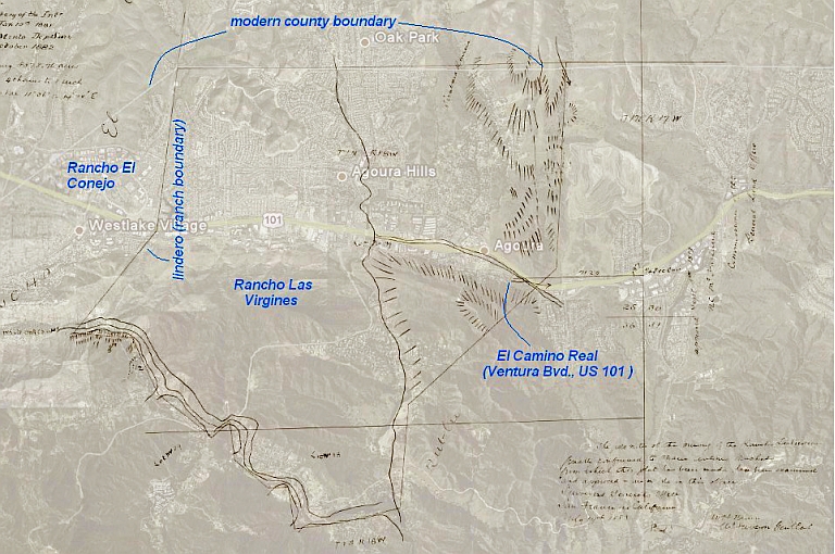
Fig.9. Showing the 1882 map overlayed on GE image
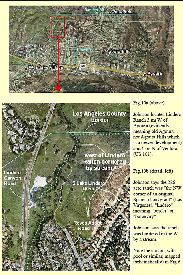
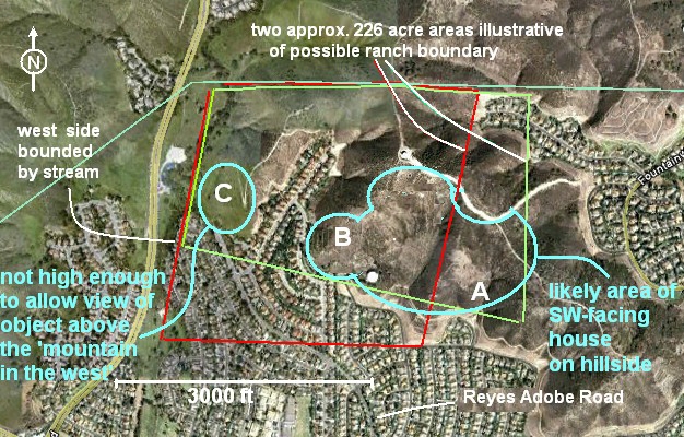
Fig. 11 Two alternative 226-acre areas (red and green) crudely illustrative of possible Lindero Ranch boundaries
Five later, more detailed maps are held by the UCLA library, including Fig.8, which shows only the west side of Las Virgenes as surveyed in 1882 when presumably the rancho was being divided for resale.25 Fig.7 shows this map overlaid to scale on a Google Earth image of the same terrain. Some details assisting identification of the location of Lindero Ranch and ranch house are shown in Figs. 10 and 11.
Fig 11 shows two possible ~226 acre quadrilaterals bordering the lindero stream on the west. These examples give an impression of the sort of land area enclosed. Clearly the true boundary might be any arbitrary shape, limited by six fixed parameters 26:
- a western stream boundary of unknown length
- a northern boundary following the LA County line
- the inclusion of some hill area that could be described as a "mountain"
- a hill location for a house with a SW view
- a house location with a view of the "mountain in the west" at ~255º azimuth
- over which the object was seen
- the probable inclusion of some area sold in 1962 for the
- 'Lake Lindero' housing development extending to 746 homes
25 Drawn at an original scale of 4 chains to one inch Bounded area given as 4878.76 acres. 1882 magnetic variation: 11º 26'. From: Diseños : Maps and plans of ranchos of Southern California, mostly within Los Angeles and Orange counties, Bound manuscripts collection, Dept of Special Collections/UCLA Library, A1713 Charles E. Young Research Library, 405 Hilgard Ave, Box 951575, Los Angeles, CA 90095-1575;
See:
http://content.cdlib.org/ark:/13030/hb2h4nb1ph/?order=17&brand=calisphere
26 A seventh parameter should be "a view of the Pacific in the southwest" as described in Kelly Johnson's autobiography. But there is no possibility of such a view from anywhere inside the Las Virgines land grant. We might speculate that the Lindero Ranch incorporated a small wedge of what was Rancho El Conejo, which would bring in some higher hills to the west of the Lindero Canyon Road. But not only would this not fit Johnson's "bounded by a stream in the west", which fixes the lindero convincingly, a careful inspection of the skylines in Google Earth shows that even from the higher 1600ft ridge west of Lindero Canyon Rd. the sea is not even close to being visible in the SW. From a rooftop on this summit you could possibly glimpse a sliver of sea horizon between hills in the WNW on a good day, but certainly nothing at all in the SW, and this site is unrealistic for any practical house site. Even looking further north and well wide of the likely area one still only finds 1800 ft hills with only a slightly improved glimpse of the sea in the same WNW direction, never SW, in which quadrant the mountain ridge never drops below ~1900 ft. We conclude that this claimed "view" was mere poetic licence, possibly introduced by Johnson's co-writer, Maggie Smith.
Given that the NW corner of the ranch is anchored by the first two
parameters, it doesn't seem possible to satisfy all these
conditions if the entire 746 homes were on the former Lindero Ranch.
We can count the extant house density on GE. In the roughly-square
area of streets below the bottom right-hand corner of the red
rectangle, for example, we get about 140 - 150 per inch2 on the
scale of Fig 11. The total number of houses within the area of the
red rectangle in Fig. 11 must be less than 300. It seems clear that,
to encompass 746 homes at this density, some version of the
226-acre red rectangle would have to be stretched so far south down the
approximate line of the stream (and therefore so compressed E-W)
that there could be little or no "mountain" left inside it at all.
So we only know that if the number of Lake Lindero development
homes on former Lindero Ranch ground is non-zero it is probably
less than a few hundred, and this parameter does not help to choose
between members of an equivalence-class of boundaries like the red
and blue areas in Fig. 9.
Turning to other parameters: Which part of the hills inside a
possible Lindero Ranch area has a SW facing aspect and a view to a
"mountain in the west" on ~255º azimuth as described in Johnson's
sighting report?27
It is a reasonable assumption that when Johnson's co-written
autobiography speaks of a house "on a mountain top with a view of
the Pacific Ocean to the southwest", the "mountain top" is as much
a figment of literary license as is the "view of the Pacific" (see
Note 22). There is no sign in GE on the hilltops anywhere in this
area of what looks like the shell or ruin or even the foundations
of a 900 ft2 concrete block house that we know was certainly still
there well after the land sale date of 1962 as it continued in use
as a Boy Scout HQ. It seems unlikely that a large concrete building
in an isolated position would have been so utterly destroyed as to
have left no trace - unless the site happens to have been right
underneath what appears to be a radar dome at ~1500ft on the very
summit of the north part of the ridge.28 But the exposure of this
site seems inherently unlikely for a domestic dwelling, and a local
source informed Mary Castner that "nothing was built over [the
house]". This argues that we should probably be looking further
south, either on a lower southern spur or down the SW facing slopes
towards the edge of the modern housing development where a
demolished or incorporated building might be more difficult to
identify.
Reyes Adobe Road, as mentioned by Mary Castner's informant, was
conceivably the natural access to the property from the south in
1953, and could be a clue to the location of the ranch house. It
runs from Ventura Bvd (US 101) directly to a low ridge between
Lindero Canyon Road and S Lindero Lake Drive to the east - Location
C in the blue ellipse to the left in Fig. 11. From positions on this
ridge the Pt Mugu spit lies close to the azimuth of 255º (True) as
stated by Johnson.
But when Johnson speaks of the object appearing to be "very large"
at an unknown distance "above a mountain to the west" he gives the
impression that the mountain concerned is one of the peaks on the
WSW horizon many miles away, whereas from Location C these peaks in
the west are not visible on the sighting LOS, which was reported as
"roughly over Pt Mugu" or "about 255º "
.
From Location C this sighting azimuth does run over the shoulder of
a nearby hilltop, ~1500 ft high and ~ 0.7 mi (1 km) away on the other side of Lindero Canyon Road,which could certainly be called a mountain, to the west. Perhaps
this is what he meant? But Johnson's 255º LOS would cross this hill
at a contour ~250ft higher than the viewpoint at Location C,
therefore ~ 4º above his astronomical horizon. The relative
elevation of the object seen by the WV-2 crew was negligible, and
they judged it to be at their own altitude or only a little above,
~17,000ft. At the range of the LOS-cross we find (allowing for
refraction in a standard atmosphere; see next section) that this
altitude would be ~4.25º above Johnson's astronomical horizon.
Fig. 12 shows that in the direction of Pt Mugu between about 255º
and 260º an object 4.25º above Johnson's astronomical horizon would
either almost abut, or be obscured by, the nearer hill line.
27 Johnson's bearings are clearly given True, i.e. from geographical North. No remotely plausible site could be consistent with a bearing to Point Mugu of 255º Magnetic given local deviation in 1953 of >15º.
28 The author has so far not managed to find any information on the date or function of this structure.
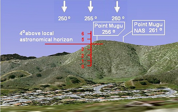
Fig.12. View from Location C in Fig.9 showing hill at 3,600 ft distance
obstructing mountain horizon at 255º azimuth.
So whilst it is not impossible that Johnson could have been looking
at it in the sky "above" this hill from Location C it is a somewhat
uncomfortable interpretation. A much more comfortable
interpretation is that the "mountain to the west" at ~255º was one
of the more distant skyline peaks, viewed therefore from a location
on the hills to the East side of the shallow valley that is now
Lake Lindero Drive, somewhere inside the approximate blue area to
the right in Fig. 11.
Fig 13 shows an horizon view from an eye altitude of nearly 1100 ft
on the side of a hill towards the SE side of this area, near
Location A in Fig. 11. Fig. 14 shows a view from an eye altitude of
1320 ft near a hilltop further W at Location B. In both of these
similar views, Johnson's LOS to the static object, on a bearing
estimated to be "about 255 degrees", lies above a group of 2-3000ft
peaks at a distance in the order of about 10 miles and more, and
roughly aligns with the distant Santa Barbara Islands (which are
well below the mountain horizon).
The view from Location B in Fig. 14 is arguably a slightly better
fit. From Location A, both the geographical feature named Pt Mugu
and the Pt Mugu Naval Air Station (it isn't clear which Johnson was
referring to) are displaced further to the right from the 255º
bearing. Whereas from Location B the geographical Pt Mugu lies at
256.5º, close enough to Johnson's "about 255º from my ranch", and
at 255º the object would be located nicely above the right-hand
peak of the mountain range on the horizon.
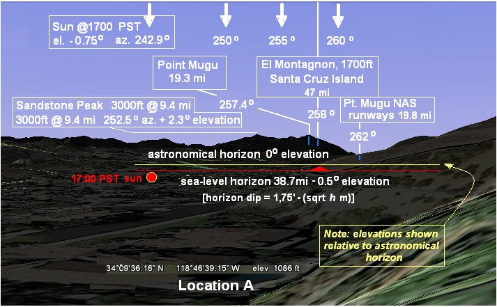
Fig 13 View from Location A in Fig. 11
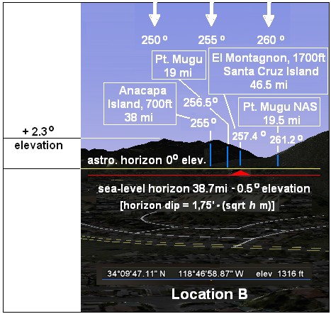
Fig. 14 View from Location B in Fig. 11, arguably the best fit
.
5. Johnson sighting geometry
The investigation in Section 4 failed to locate the 1953 Lindero
Ranch house precisely but succeeded in narrowing down the probable
location to the area of point B in Fig. 11. The uncertainties are
evidently in the order of a hundred metres. This is close enough to
be useful. The view in the sighting direction from this approximate
representative location is as shown in Fig. 14 with bearings and
elevations shown relative to the astronomical horizon. Clearly,
whereas the airborne WV-2 observers had no visual obstructions at
their altitude, the 3000ft mountains on the horizon are a
significant potential obstruction for the Johnsons in the line of
sight to an object in the air tens of miles away. We need to find
out whether Johnson could indeed have seen an object at the
location and altitude indicated by the airborne observers on the
WV-2.
Our problem then is to estimate, for an observer at a given
altitude ASL, the apparent vertical angular position, including
displacement due to refraction, of a target object at a given
ground distance and at a different altitude ASL. Assuming for
simplicity a constant environmental temperature lapse rate, with no
inversions or other nonlinearity, we can make use of an
approximation due to Andy Young which gives elevations relative to
the astronomical horizon.29
In order to implement this algorithm we need to estimate the environmental lapse rate through the column of air in question. For many purposes meteorologists assume the free-air (i.e., elevated, not near-ground) lapse rate through the entire troposphere (Fig. 15) to be the ICAO Standard Atmosphere rate of about 6.5ºC/km.30 Of course a Standard Atmosphere is often a valid approximation to the average rate but will rarely be totally realistic. In the present case we have some useful data in the form of radiosonde profiles31 obtained at 1900 PST at two stations somewhat south and north of the line of sight, which can be compared with literature studies of typical lapse rates over the area.
29 The astronomical horizon is an horizontal tangent plane containing the eye of the observer. It appears to contain all points that are actually contained in a curved surface defined by the set of all light rays that are horizontal at the eye of the observer, but which in fact have curvature due to atmospheric refraction. This set of rays usually forms a surface with a radius of curvature much larger than that of the Earth. All points anywhere in this surface intersected by these rays are, in principle, at the same visual elevation for this observer, which is the plane of the astronomical horizon, always some angular elevation above the apparent or terrestrial horizon (depending on eye altitude).
The astronomical horizon curvature is determined by the temperature lapse rate which governs the refractivity along the optical path. So if we know the lapse rate we can find the ray curvature, which then determines the true metrical height above the Earth's surface of the observer's astronomical horizon, HH, at the distance d of the target object. Finally the angular height of the target point above the observer's astronomical horizon can be calculated approximately in plane geometry from the metrical height of a line dropped from the target to its intersection with the astronomical horizon below it.
Young's method adopts an effective Earth curvature equal to the difference between the true geometrical Earth surface curvature and the curvature of the refracted light ray, which is as though the Earth's radius of curvature R had been replaced by an effective curvature
R
eff =
R/(1-
k)
where
k is the ratio of curvatures
k = (35-γ)/150
where γ is the lapse rate, in ºC per km, and the distance to the horizon is given by the formula
d2 = 2hReff = 2hR/(1-
k)
where
d is the distance to the horizon, and
h is the height of the eye above the surface that forms the apparent horizon, i.e., the horizon between the surface of the earth (or sea) and sky as seen by the eye in conditions of atmospheric refraction, as opposed to the true geometric horizon (which would be seen in a vacuum).
Because the assumed constant lapse rate produces no image distortion, simple geometry can then be used to determine the angular elevations of light rays above an effectively plane surface. The angular altitude of the target
T above the observer's astronomical horizon is just the angle subtended by the height difference (
Htarget– H
H) at a distance
d, or (H
target–H
H) /
d radians, except that Young's algorithm includes an additional factor of exp(
-H/8 km) which corrects for the decrease in atmospheric density with height.
See:
http://mintaka.sdsu.edu/GF/explain/atmos_refr/altitudes.html
Atmosphere rate of about 6.5ºC/km.30 Of course a Standard Atmosphere is often a valid approximation to the average rate but will rarely be totally realistic. In the present case we have some useful data in the form of radiosonde profiles31 obtained at 1900 PST at two stations somewhat south and north of the line of sight, which can be compared with literature studies of typical lapse rates over the area.
The radiosonde profiles (Section 7, Figs 16 & 17) show evidence of a typical marine inversion below about 5-600m - well below the body of air of direct interest to us here - and above this level very anodyne average lapse rates of 6.7ºC/km and 6.8ºC/km at Long Beach and Santa Maria respectively with no further sign of any significant anomalies. This rate appears to be fairly typical of conditions aloft on this coast. One study of average lapse rates measured from balloon sites at UCLA and Santa Ana between 3050m and 6100m (10,000 - 20,000ft) shows diurnal variation between about~6.5ºC/km and 7.0ºC/km.32
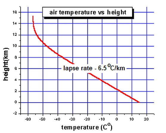
Fig.15. The average free-air lapse rate in the troposphere (Canadian Space Agency33)
Of course, about half of the optical path from Agoura to Anacapa Island is over the sea where we have no measurements, and the physics of the atmosphere are modified here by two other factors: The sea surface temperature (SST); and the moist marine boundary layer (MABL).
An inversion gradient in the MABL appears to be the norm, although it tends to be much weaker in winter. The SST does not vary greatly in this area and remains quite cool, summer and winter, but is a little colder in December. According to NODC figures34 the historical December SST average at Anacapa and Pt Mugu is 59ºF (15ºC), which would tend to cool air offshore at the bottom of the marine layer, helping any low-level inversion gradient in the layer. When the MABL is thin and the inversion layer is compressed close to the sea, as often happens especially in summer, the California coast is prone to mirage events. When marine fog does not obstruct visibility, remarkable Fata Morgana mirages of the islands are not uncommon.
32 Leopold, L.B. & C.G.P. Greer, 'The Coastal Sea Breeze in Relation to Diurnal Temperature Changes in the Lower Atmosphere (Southern California)', Bulletin of the American Meteorological Society, VoI. 2 Oct 1947 pp. 371-380
But of course sea-level lapse rate anomalies are insignificant for our present purposes, and the radiosonde profiles illustrate the way in which MABL conditions can be decoupled from the near-standard atmosphere above by an inversion layer. The question is how thick the MABL inversion can be. Might the height of the layer be significantly greater over the sea than that measured at the balloon release sites on the coast and cause refractive index anomalies in the rising line of sight from Agoura?
Off the coast of California, the top of the MABL is typically the top of a subsidence inversion, which in summer is marked often by a fog bank in the case of a shallow MABL (generally <400m) or by an elevated layer of stratus cloud in the case of a deeper MABL (>400m).35 In winter these features are less well defined. In winter the subsidence-causing Pacific High that controls MABL depth retreats out to sea, the vertical temperature difference across the MABL is reduced (partly because the relatively stable SST drops less in winter than does the air temperature), and the layer grows much deeper, less stable, more under the influence of passing cyclones and fronts.
So, in general, a weaker, intermittent inversion is capped by less well-defined cloud at a higher altitude than is the case in summer. Stratus and fog events still occur, but generally the cloud is higher, more broken, and tends to stay out at sea, so there is only a 5% chance on any given winter day of a fog or stratus event on land.36 This pattern appears to fit the conditions reported on Dec 16 1953 (generally clear on land, broken overcast at sea).
But even as the top of the MABL rises and weakens it very rarely extends above 1500m.37 So it seems unlikely that any unsampled MABL-related lapse rate anomaly over the sea will be a factor significantly affecting the behaviour of light rays along the line of sight of interest to us, which passes through air below this altitude only inland, mostly in the lee of the coastal mountains.
From the ground, at Agoura, Clarence Johnson observed "several thin layers of clouds or haze" at or near the line-of-sight elevation of the object, which were "coming onshore", i.e. moving generally W to E, at "fairly high altitude". The object seen by the Johnsons was "moving behind" such a layer. Clarence Johnson offered no estimate of cloud height. But given that "at fairly high altitude" means (at least) above the mountains in the sighting direction we can say that the minimum possible height of the lowest layer must have been more than 3000ft ASL, and arguably "fairly high altitude", coming from an extremely experienced aeronautical professional like Johnson familiar with cloud types and heights, implies an altitude significantly higher than this and much higher than any likely MABL-related feature. It has yet to be demonstrated that the Johnsons had a line of sight to the position of the object reported by the WV-2 crew, but it may be that they were observing the cloud layer noted by pilot Wimmer just below the object ~16,000 ft over the Santa Barbara Channel area, and a lower, thinner layer nearer the coast associated with the "very thin scattered overcast" at ~14,000 ft observed by WV-2 copilot Rudy Thoren further south.38
So it seems very unlikely that the inversion in the semi-permanent marine boundary layer, even if imperfectly represented by the coastal radiosonde profiles, plays a part directly in the structure of the atmosphere along the Johnsons' line of sight. It is of course always possible in principle that the cloud layers marked sharp elevated inversions that happened to fall between the radiosonde data points. But it seems fair to say there is no evidence of significant (for our present purpose) departures from an ICAO Standard Atmosphere lapse rate through the column of air in the ascending line of sight from Johnson to a target at 16-17,000ft some 20 mi out over the open sea.
35 Leipper, D.F., 'Fog on the United States West Coast: a review' Bull. Amer. Meteor. Soc., 75 (1994), pp.229-240
36 Askins, John, The Marine Layer, Coastal Fog, and the Los Angeles Basin.
37 Jordan, Mary S., &.Philip A. Durkee, 'Verification and Validation of the Satellite Marine-layer/Elevated Duct Height (SMDH) Technique', Space and Naval Warfare Systems Command NPS-MR-01-001 December 2000
38 Thoren reported being at the controls and climbing through a "very thin scattered overcast". From Section 3 we
know that Thoren was flying on the 3rd leg of the flight (see Fig.2) shortly after the start of the climb from 10,000ft at Point 3, which is consistent with Thoren's estimate that the overcast was at about 14,000 ft. We can estimate that the WV-2 would have passed through 14,000ft, climbing SE at a ROC of ~600 fpm, a couple of minutes before reaching the area of the W turn at Point 4, therefore at approximately 16:53 PST. It was after the turn, with the WV-2 now heading W at ~16,000ft at ~16:58 PST, when pilot Roy Wimmer noted the object above what seems to have been a separate "cloud layer" over the ocean "starting somewhere east of Santa Cruz island at about our altitude". Both of these cloud layers noted by the WV-2 crew are about 3 times as high as the highest likely MABL-top stratus.
Given this conclusion we can apply Young's algorithm. For the case where the observer is at
~1000ft and the target is at ~17,000ft, and for an environmental lapse rate of 6.7°C/km, we find the ratio of curvatures of horizontal rays and the Earth's surface, k? =? 0.135, and with the target at a distance of 38.6 mi (62.12km) at the triangulated location roughly above Anacapa Island, we find the apparent altitude of the target is
254.9 arcmin = 4.25º
above the astronomical horizon, meaning that this object would appear from Lindero Ranch to be at about 255º azimuth as reported, within a degree or so of the bearing to Point Mugu as reported, and approximately 2º above the mountain peak seen in Fig 14. We conclude that the position and altitude of the object reported by the airborne observers on the WV-2 is generally consistent with the description by Johnson of the object seen low in the sky, against the sunset, "above a mountain to the west".
6. Triangulated sighting geometry: apparent object position and motion
In Sections 3 and 4 we studied the observer locations and lines of sight (LOS), leading to the reconstruction in Fig. 2 which establishes the length of the baseline for the synchronous triangulated sightings by the Johnsons and the WV-2 crew. The separation of the two ends of this baseline varies around a figure of 40 mi ± ~10%. Error brackets on the Johnson sighting position are in the order of 100m and are negligible. Brackets on the WV-2 position set by general geographical constraints in the observer accounts allow some margin for error around the best-fit position, but it is estimated that the maximum uncertainty in the average bearing angle from the WV-2 is no more than ± 10º, the likely uncertainty less than half this figure (again about 10%). Therefore the approximate 40º angle subtended at the point of intersection of the two LOSs is at least four times the likely maximum uncertainty and so is a significant angle with consequences for our interpretation of the reported apparent position and motion of the object.
Clarence Johnson reported that the object viewed by himself and his wife from the ranch house in Agoura Hills appeared stationary for at least 3 min and then climbed away from them at speed. He says he could infer the speed of this recession from the rate of diminution of angular size, but nowhere does he say explicitly that he detected any transverse angular rate, either in azimuth or elevation. It may however be possible to infer transverse angular rates from Johnson's statement.
The first possible allusion to an azimuth rate is extremely weak evidence. Johnson's first mention of the object's position is "above a mountain to the west", whereas at the end of his report he gives a bearing "about 255 degrees" or about 15 degrees away from true west. One could interpret this as meaning that the object appeared initially stationary at 270º and then climbed away with a component of motion towards the south on departure. But there are several reasons to doubt this interpretation.
At 270º from the likely observation point the visibility of an object above the nearer hills (less comfortable candidates for the "mountain") at the elevation calculated in Section 5 would have been marginal (see Section 4), and would have been nearly 15º away from the specified reference bearing of Pt Mugu. Moreover the implied trajectory to the south would be in the wrong direction to easily explain the fact that the simultaneous observers near Long Beach observed their object to vanish on a line of sight away from them at ~295º, or significantly to the north of west. For consistency, if these are triangulated sightings of the same object, Johnson should have described the object climbing away to his right, not to his left. It may be that with some ingenuity a scenario could be reconstructed which would resolve this consistently, but it seems at least equally plausible that Johnson is merely refining the value of a single constant bearing given initially to a gross approximation.
The second allusion to a possible azimuth rate occurs when Johnson describes observing the departing object in his binoculars:
As soon as I was given the glasses, I ran outside and started to focus the glasses on the object, which now was moving fast on a heading between 240º and 260º. When I got the glasses focused on the object, it was already moving behind the first layer of haze. I gathered its speed was very high, because of the rate of fore-shortening of its major axis . . . In 90 seconds from the time it started to move, the object had disappeared, in a long shallow climb in the heading noted.
This seems more promising, but these are ambiguous statements needing careful interpretation.
Arguably "the heading noted" refers directly to the statement that the disappearing object was "moving fast on a heading between 240º and 260º", and his use of this word "heading" twice is significant. A "heading" is obviously a vector, not a position. Had Johnson said the object disappeared "on [or at] the bearing noted" rather than "on/in the heading noted" then it would have been clear that its apparent motion had no azimuthal component transverse to the line of sight and that "between 240º and 260º" was offered as a bracketed approximation, modifying the initial "to the west" and later to be refined further to "about 255º".39 But as it is, whilst he could have meant that it dwindled on an apparent heading exactly in the line of sight at 255º, the possibility arises that Johnson intended "moving fast on a heading between 240º and 260º" to indicate a change of visual bearing from 240º to 260º, being the azimuthal projection of a heading away from him with a transverse vector component of motion to his right (north) which could possibly be consistent with a sighting of the same object receding in the line of sight from the WV-2 observers.
In support of the vector interpretation we can note that Johnson seems to have been somewhat sure of the bearing of the object whilst it "hovered stationary for at least three minutes", putting it "roughly over Pt Mugu, which lies on a bearing of about 255º from my ranch" and also "above a mountain" on a familiar skyline which would have provided a useful reference (see Figs. 13 & 14, Section 4). Arguably, this indicates that he was surer of this position than would have required an error bracket around it as large as 20º. Moreover, even if he was so unsure as to offer a 20º error bracket around his estimate of 255º, why not ± 10º, i.e. 245º - 265º? Why this odd asymmetric bracket of +5º to -15º? That would seem an extremely peculiar intent for a design engineer of Johnson's calibre. So it is a respectable interpretation that "moving fast on a heading between 240º and 260º" probably does imply a vector, therefore not a recession in the line of sight. On the other hand, this does seem a slightly clumsy and ambiguous way for an aviation expert like Johnson to define a heading. And if the long stationarity at 255º is reliable, then how come the departure vector begins at 240º? Was he offering "Pt Mugu . . . about 255º" only as an extremely "rough" midpoint?
It has to be admitted that there is no single wholly unambiguous interpretation of the several azimuth figures mentioned by Johnson. Did the object move laterally or not? We can make a plausible but flawed case for both interpretations. Suffice to say that if it did move laterally, then it appears to have moved somewhat to Johnson's right (north)
39 It seems highly unlikely that an expert witness like Johnson would have confused "heading" and "bearing" and used the former to indicate a position
When we consider transverse angular motion in elevation the situation seems at first sight no less ambiguous. A "long shallow climb" directly away from Johnson does not necessarily guarantee any displacement in elevation, since an object in the sky above the horizon obviously sits on a rising line of sight. In fact from Section 5 we are able to say that the object in the sky "above a mountain to the west" must have been at least ~2.3º above the astronomical horizon, and ~2.8º above the invisible sea level horizon, probably more (we showed that an elevation consistent with the altitude and distance of the object seen by the WV-2 crew would be ~4.25º or ~4.75º above the invisible sea level horizon). An apparent angle of climb on a line of sight rising by only a few degrees is certainly nothing if not "shallow".
Considering separately the observations by the WV-2 crew, their language can be read to suggest that they may have observed the dwindling object drift towards the left, "to the west" and "towards the setting sun". Our best reconstruction (Section 3, Fig.2) places the object initially on a LOS of 295º true, which is 10º north of Magnetic west and >50º north of the sun azimuth. A departure due west from here would imply a rotation from the initial LOS towards the west. But the implication is not very clear. There is no explicit evidence that they observed any angular displacement either in bearing or in elevation:
- Wimmer reported that they turned and "flew directly towards it for about five minutes and our relative position did not appear to change" until "I suddenly realised it was moving away from us heading straight west. . . . it grew smaller and disappeared."
- Thoren said it "appeared to be absolutely stationary" then "seemed to be getting smaller . . . reduced in size to a mere speck, and then disappeared. Its direction was almost due west."
- Ware said that "it seemed to be stationary, although we did not appear to overtake it at all" then "it became apparent that it was moving away from us" until it "completely disappeared. . . in a generally westward direction (toward the setting sun)."
- Colman said the object was "apparently standing still in the air . . . silhouetted against a bright background . . . due to the fact that the sun was just setting". They approached without "any change of impression" until it "suddenly accelerated due west and . . . disappeared from view".40
So, summarising the above: It is possible to interpret certain statements of both observer groups as indicating lateral motion, but this is ambiguous. It is in some ways easier to infer that the object dwindled in place without lateral motion, giving each group separately the illusion that it receded along their own line of sight.
However, Brad Sparks41 has drawn attention to evidence from Johnson's report which does seem to indicate a non-zero true angular rate at least in elevation. Johnson says: "When I got the glasses focused on the object, it was already moving behind the first layer of haze." It is at least arguable that only an apparent change in angular elevation can comfortably explain Johnson's statement that during the 90 seconds of what he described as the object's "long shallow climb" he watched it "move fast" behind one of "several thin layers of clouds or haze".
40 The sun was actually at 243º, about 27º S of due W and 40º to the left of their probable heading, but it had "gone below the horizon" [Thoren], had "just set" [Wimmer], so was not in the observers' direct field of view at the time. References to the "setting sun" by Ware and the sun "just setting" by Colman are apparently loose allusions to the general time frame and the immediately post-sunset sky brightness. Thoren said "At the time, the sun had gone below the horizon but the sky was red, and this object had been silhouetted perfectly against this red background."
41 Emails to the author, Oct 2005.
We can extend this argument: The clouds themselves were moving, of course, as Johnson himself described, and illusions of relative motion are well understood. But in my opinion a true angular displacement of the object relative to the horizon is made more convincing because Johnson elsewhere tells us that the object's direction of apparent departure away from him (roughly WSW) was opposite to the direction in which the clouds were moving under the influence of an onshore wind. This reported direction is consistent with weather maps for the day in question recording 700mbar winds from the SW and surface met obs indicating cloud movement generally W-E (see Section 3).
If the clouds had been moving offshore, away from Johnson, then they would have been moving down the sky, and it would have been at least possible for a stationary object to give the illusion of rising behind a cloud when in fact the angular elevation of a moving layer of cloud was falling. Especially when viewing in hand-held binoculars (as Johnson was) it might be easy to be deceived about such relative motions. But because the clouds were approaching from the W any perceptible cloud movement would have been movement up the sky (and Johnson's visual judgment that the cloud was approaching more or less guarantees this), so any relative apparent movement of a stationary object might have given an illusion of a descent, but not of a climb.
Johnson uses the phrase "already moving behind" which gives an impression of observing the object in the act of going behind the cloud. But his account shows that this refers to the first moments after a discontinuity in his observation, just after he focused the binoculars on the object. He does not explicitly say that he saw the elevations of the object and of the cloud changing relative to one another. Could it not be the case that during the time it took Johnson to go outside with his binoculars one of the layers of approaching cloud previously just below the object had indeed moved up the sky so that it now appeared to lie across the object? If at this point the object began to diminish in size in the binoculars, suggesting a shallow (few degrees) receeding climb in the line of sight, might this account for a description of recession at a speed that was "very high" when the object had apparently moved "behind the first layer of haze"?
Johnson's account gives us the answer: The layer behind which the object appeared to climb was the "first" - i.e., presumably the lowest - of the several layers of "high altitude" cloud. There was no layer of cloud below the object.42 Therefore it appears that unless the object gained real elevation the approaching layer(s) would need to have dropped significantly in angular elevation, not risen, which is geometrically and physically difficult to conceive.
A drop in the apparent height of an approaching cloud would require a true drop in cloud height through an altitude whose subtended angle at the observer's eye is greater than the geometrical increase in angular elevation due to the reducing ground distance. True descent of a cloud can occur due to subsidence of the air mass containing the cloud, and subsidence might be triggered by frontal movements. Rates of subsidence as high as 2 - 4cm.sec-1 have been "considered plausible".43 Typical rates of subsidence actually measured off the coast of California are in the region of 0.25cm.sec-1.44 A rate of motion in the order of a centimetre per second at a distance of at least ~32 km (20 miles; see below) corresponds to an angular rate of only about 0.006 seconds of arc per second. Since this rate of displacement would not accumulate to the nominal 1 arcminute minimum angular resolution acuity of the human eye in less than about 17 minutes (more than three times the entire length of the observation) we conclude that the contribution of subsidence is entirely negligible, and therefore the approaching cloud layer was undergoing a geometrical increase in angular elevation, as of course is implied by Johnson's visual judgment (proven correct by the weather data) that the cloud was indeed approaching.
42 That is to say, from Johnson's position the cloud layers near the initially static object appeared higher than the object. This is also implicit in Johnson's initial impressions a) that the object was a low-level lenticular or mountain wave cloud "above a mountain" on the western skyline, and b) that it was approximately over Point Mugu, again suggesting relatively low (a few thousand feet) apparent altitude, which is in contrast with his simultaneous impression that the cloud layers were at "fairly high altitude". However this is not to say that airborne obsevers looking from a direction 40º further south and near co-altitude at 17,000ft might not see the same object appearing "above" a different layer of cloud lying beyond it, i.e. further north and thus displaced to the right of Johnson's line of sight to the object. This would fit what the WV-2 observers reported.
43 This rate is calculated to suffice for the entire evaporation of a 300m thick layer of cloud in the unusually rapid time of 2 - 4 hrs and would presumably be extreme for high-altitude subsidence in the free atmosphere (as opposed to situations of topographical forcing, as in the lee of a mountain barrier).
So there is quite good internal evidence that the object exhibited a true gain in angular elevation relative to a cloud which was also gaining angular elevation. And this allows us to calculate an approximate lower bound on the object's true absolute rate of angular climb.
The lower scattered overcast at 14,000 ft was encountered by the WV-2 near the coast, with a higher layer starting over the sea. The cloud or haze layers seen by Johnson near the object's low (~4º) elevation were, consistently, judged by Johnson to be at "fairly high altitude" and therefore also well beyond the mountains, i.e. over the coast or coastal waters. Let us assume a representative distance of 20 mi. The US weather service daily map (Fig 4) shows winds aloft at 700mbar (~10,000ft) were around Force 4 (11-15 kt) from the SW. So assuming cloud moving horizontally at 14,000ft (this is to be conservative; cloud at the higher reported level would increase the angular rate per knot of wind) and approaching at 15kt (25 fps) we get, for the cloud, a conservative naked- eye rate of increase of angular elevation at Johnson's position (located ~1000ft ASL) of approximately 6 arcsec.sec-1.
Therefore it is reasonable to conclude that the probable minimum true elevation rate of the object was in the order of 10 arcsec.sec-1. Johnson's estimate that it disappeared "in 90 seconds from the time it started to move" thus implies a total true elevation gain of ~15 arcmin, or half the diameter of the full moon. This is not a negligible angle even for the naked eye, with a nearby mountain horizon to provide a good frame of reference; and for typical 8x40 binoculars with an FOV in the region of 6º- 7º it corresponds to about 1/25 the apparent field of view. The mountain crests would be visible simultaneously with the FOV centred on the object. The total elevation gain of the object is about 11% of the vertical angular height of the mountains immediately beneath it, which would not be difficult to observe at 8x magnification, becoming an effective or apparent visual angle of fully 2°, or a vertical displacement equal to four naked-eye lunar diameters, traversed at an effective binocular rate of >1 arcmin.sec-1 .
In summary, evidence of lateral motion is ambiguous, especially in the WV-2 reports. But for Johnson the object must have had a positive angular rate in elevation which is calibrated for us quite nicely by the fact of its "moving behind" the approaching cloud as it appeared to climb away. It is also true that the presence of such an angular motion gauge permits a more comfortable interpretation of Johnson's report of a "climb". A line-of-sight recession without angular displacement, at the very low elevation of just a couple of degrees above the mountain horizon, would certainly be a "shallow" climb, strictly speaking, but arguably so shallow as to be negligible.
7. Interpretation
The observers' own changing impressions during the sighting were as follows:
- Johnson (ground observer) initially thought it was an unusually dark and dense "black cloud", then speculated that it was "an intense smoke trail" made by an aircraft, then when it didn't move he reverted to "lenticular cloud", but because it remained "black and distinct" and then climbed away without any change of shape he concluded that it was a "so-called 'saucer'".
44 Cotton, W.R., Bryan, G., Van den Heever, S.C., Storm and Cloud Dynamics, Academic Press (Elsevier) 2011 p.226
- Wimmer (pilot) initially thought it was "a small cloud", joked that it was "a flying saucer", then decided that it was "not a cloud" but "some kind of object" with a "definite shape", crescent or wing shaped, "a large object some distance away".
- Thoren (co-pilot) initially considered and discounted Wimmer's first impression that it was a small cloud, concluding that it was "some sort of object" with "definite sharp edges" looking like "a very large flying wing airplane"
- Ware (test section supervisor) initially had the impression of "a large airplane, possibly a C- 124", but discounted this after observing its lenticular profile and because they "did not appear to overtake it at all".
- Colman (aerodynamicist) initially saw something like "a B-36 type airplane heading straight towards us" making a "thin black line" in silhouette, but it did not appear to move. He also discounted the possibility of "a cloud phenomenon" later, partly because of the triangulated observations.
The observers collectively considered and dismissed the possibilities of some sort of smoke trail, a well-defined small cloud (possibly a mountain wave or lenticular cloud, altocumulus lenticularis), or some sort of conventional aircraft. All became convinced that they were seeing a large solid object capable of hover and rapid flight. With the exception of one remark by Thoren ("the fact that what [Johnson] saw and what we saw appears to be identical . . . leads me to believe it was not exactly an illusion that I observed") there is no indication that anyone seriously considered the possibility of an atmospheric optical effect, i.e some sort of mirage. But clearly this also needs to be considered.
Aircraft
Two of the observers (Ware and Colman) started with an initial impression that it could have been a large conventional aircraft seen head- or tail-on, but rapidly abandoned the theory. There is obviously no hope of tracing aircraft movements after nearly 60 years, but the fact that the Air Force apparently gave this idea scant consideration and dismissed the case as a lenticular cloud may be indicative. In any case this theory appears to be ruled out by the triangulation, demanding an extended period of near-hover and implying a true size of several hundred meters. Of course this assumes that both groups of observers were seeing the same object - coincidental sightings of two different unidentified aircraft receding on the two LOSs simultaneously would seem exceedingly unlikely and inelegant, but not impossible.
What if the WV-2 itself played the role of UFO for the Johnsons? Could the big Constellation have been seen tail-on in silhouette, appearing to hover for some time against the sunset as it headed out to sea past Agoura from the Lockheed Air terminal at Burbank? No. The 16:29 PST take-off time is known and in order to make the other fixed time-stages in Fig 2 the plane would have to have been well out to sea and turning away south within 10 mins of take-off, or 20 min before Johnson first saw the object. So it is unworkable without some very implausible timing errors, not to mention that it seems incredible that Clarence Johnson could have failed to recognise an aircraft in the conditions described - especially one he had himself been largely responsible for designing.45
Could the elliptical or lenticular shape observed by Johnson be explained by an aerodynamic
contrail, if not around the WV-2 then around some other untraced aircraft? Sometimes sheets of vapour form over the lifting surfaces of high-performance aircraft creating a smooth cone or shroud that can envelop the whole airframe and might appear very strange. (Basically this is a type of wave cloud triggered by a moving plane and so is a close relative of the lenticular cloud. See p.45) In the right conditions a large bomber might cause such an effect (Fig.16) which has been well-known since WW II. But the plane needs to put on a lot of power or pull high acceleration in manoeuvre to achieve the pressure drop, preferably in moist, warm air close to the dew point, so is especially unlikely in the sub-zero air at 17,000 ft with relative humidity low (<35%, Long Beach ascent, Fig. 17) and with a plane flying slow enough to appear unmoving for several minutes.46
Fig.16 Photo, from LIFE magazine, October 4 1954, showing an RAF Vickers Valiant
forming an aerodynamic contrail during an air display at Farnborough47
The triangulated observations would appear to imply a very large object in a stationary hover for a period of at least five minutes, which would clearly rule out any kind of conventional aircraft except a lighter-than-air (LTA) aerostat or dirigible. On the other hand if the rapid climbing departure was correctly observed by Johnson (Section 6) this would also rule out a LTA craft.
An apparent disappearance in place also seems to rule out any kind of aircraft. A dwindling disappearance could conceivably be explained by the deflation of a ruptured LTA gasbag; but it seems entirely unrealistic that such a large vehicle could shrink monotonically to the point of total invisibility (i.e., not a catastrophic burst but a steady shape-preserving dwindling over the space of a few tens of seconds) whilst being watched by several pairs of sharp test-pilots' eyes and another expert observer armed with binoculars, when the atmosphere was "extremely clear" (Thoren), "very clear and the light was real good towards the west" (Wimmer), and "the horizon was well-defined by the rays of the setting sun, and the sky above the overcast was clear" (Ware). Moreover the loss of buoyancy would result in the remains of the vehicle falling during deflation, which was not observed (indeed Johnson observed an ascent).
If a type of conventional air vehicle is ruled out, what about some sort of classified unconventional
test vehicle? Evidently neither the Air Force nor top employees of a well-connected cutting-edge defence contractor like Lockheed were aware of any such development in Lockheed's "back yard". But the whole area was rich with military and civil airfields and construction and test and operational facilities of various kinds, the Lockheed Air Terminal at Burbank (home of the WV-2 ) being a case in point. And it might be considered significant that the location was some miles off Point Mugu, home of the Point Mugu Naval Air Station and the Navy test flight centre.48 But no candidate programme has emerged in the intervening decades. And in 1953 what type of vehicle, secret or not, could have behaved in the way described and implied?
There is an ingenious construction due to Brad Sparks49 which could possibly rescue the impression, received by all observers, of a high-speed recession approximately in the line of sight. The main key to this is timing and the 8x longer duration of recession visible to Johnson in 8-power binoculars. It is not my intention, or my place, to explicate Sparks' scenario here in detail; but in terms of the reconstruction presented here the basic idea suggests the following sequence.
When the object begins to recede away from the WV-2 the plane is in excess of about 60 mi from the triangulated location (Fig.2) and seen from the plane the object has a naked-eye angular size only 2/3 the size it has for Johnson, 40 mi away. At this time Johnson breaks off to go outside the house, and the object begins dwindling away from the WV-2 on ~295º (True). By the time Johnson gets outside it is already disappearing below resolvable angular size for the naked-eye observers on board the WV-2, but for Johnson it is still a marginal naked-eye object, because its vector component of motion away from him on 295º is smaller and it had a larger angular size to begin with. At the same time the object is now making a westerly turn through about 40º, taking it away from Johnson, so although it is now displaced somewhat to his right since he first observed it in the house, he has not seen the object moving significantly.50 By the time he gets his binoculars focused on it it is "already moving fast behind the first layer of cloud" on a heading around 255º as he described it, remaining perceptible in the 8-power binoculars for a further 90 seconds.
Whether this or a similar construction can be made to work with precision is not clear, but it certainly merits study. However even if it were possible to rescue the theory of some type of aircraft, the idea still only works with an extended initial hover (several minutes at least) followed by extreme acceleration, which rules out conventional aircraft performance. Therefore this is not an obviously conservative hypothesis.
A further issue is angular size. None of the observers gave an explicit estimate of angular size, but Thoren stated that his initial impression was that the apparent size was equivalent to that of "a very large flying wing airplane . . . probably seven miles away". The Northrop YB-49 is the flying wing programme with which Thoren would most likely have been familiar.51 The wing had a span of 172 ft, so Thoren's qualifier "very large" leads us to suppose that he had in mind something at least this size, perhaps 200 ft. (Ware's first impression was of "a large airplane, possibly a C-124 [Globemaster]" which had a wingspan of 174ft, whilst Colman had "a first reaction of a B-36 type airplane" with a span of 230 ft.) So Thoren's implied angular size estimate is Tan 200/37,000 = about 0.3º or 18 arcmin. This is nearly 2/3 the angular width of the full moon, many times the smallest angular subtense for the resolution of a shape by the naked eye, and therefore consistent with Thoren's stated ability to resolve the shape of a wing-like section with "definite sharp edges" which "exactly matched" the description of a 7:1 aspect-ratio ellipse given by Johnson.
49 Various emails to the author.
50 If Johnson had the impression that the object's bearing had changed, but missed actually seeing it move, this might explain the ambiguity in Johnson's report of the object's azimuth (see Section 6).
However, Thoren himself later concluded that the object was "considerably larger" and the distance "much greater" than his initial impression. Indeed, extending our chain of inference further leads (in terms of the reconstructed sighting geometry in Fig.2) to an implied true size approximately an order of magnitude larger. At 60 miles, for example - about the mid-range of the WV-2's reducing distance from the sighting LOS intersection over Anacapa Island - the implied object width would be approximately 1700 ft (520m). Such a very large object (which would initially have subtended almost 0.5º to the naked eye for Johnson, observing from Agoura, assuming symmetry of revolution) is obviously very difficult to square with any imaginable kind of aircraft, secret programme or not.52 Of course the above chain of quantitative inference is fragile and should be treated with caution.
The set of circumstances required by the aircraft theory is also undeniably fortuitous, and is open to the charge that it is overly complicated when we have available what is in a certain sense a simpler prima facie interpretation - that some object, or the mere image of an object, shrank and vanished. But on the other hand a simple assumption can have very complicated implications. It is far from clear at this stage that we have a good theory to explain this apparent behaviour either.
Mirage
Taken individually, either observation of a dark blob dwindling and vanishing without apparent lateral motion could be thought suggestive of a mirage image of some kind. Inversion conditions conducive to superior mirage are quite common off parts of the California coast. It might be suspected that inversion layers of large horizontal extent would tend to favour hot summer days rather than the middle of December; but there is only a very small seasonal difference in the frequency of inversions on the coast of California, and in fact the frequency is even a few percent higher during the winter months.53
Localised coastal inversions may develop due to the seaward advection of warmed air from the land over the top of cooler air near the ocean surface, aided by the daytime seabreeze circulation; intruding weather fronts may slide wedges of cold air underneath warmer air; and radiation inversions may develop at night. But the most notable and relevant are the widespread sharp inversions capping the marine layer, caused by adiabatic warming of air subsiding over cooler air near the ocean surface. Elevated inversion layers, typically a couple of thousand feet thick, sometimes narrower with vertical gradients in the order of a degree C per meter, may also occur due to subsidence, usually in the range 6000 - 10,000ft but sometimes as high as about 20,000ft.54 55
Unfortunately the mirage theory encounters a variety of problems.
Generally, where two mirage-like images of similar appearance and in a similar apparent location shrink and vanish at approximately the same moment it would be reasonable to suspect the same optical mechanism. Widely separated raypaths inside an elevated inversion layer might have a similar optical history if the layer is of wide horizontal extent, as is commonly the case. Such elevated layers can form stable ducts spanning tens or even hundreds of miles in the right conditions, guiding light rays from far beyond the normal horizon. Two different mirages in divergent directions could occur by chance, caused by the same widespread conditions.
52 The envelope of a giant LTA dirigible or similar might conceivably be so large (see above); but of course such a vehicle cannot climb out at the "very high speed" reported
53 Viezee, W., 'Optical Mirage', in: Condon, E.U., Scientific Study of Unidentified Flying Objects, Vision Press 1970,
620-621
55 Viezee, W., op.cit p.618
But because the observers' positions and sighting bearings are rather well-established, the well- understood geometry of mirage means that the convergent raypaths 40º apart need not only to have passed through very similar anomalous optical propagation conditions to locations 40 miles apart, but also to have done so from distant targets capable of producing similar images but also situated 40º of azimuth (and therefore many tens of miles) apart. In other words the sightings are not explainable as the same mirage.
Considering the WV-2 sighting: Wimmer observed the object just above a cloud layer "starting somewhere east of Santa Cruz island at about our altitude", i.e. close to zero degrees relative elevation. The object was "well out in the clear air" above this cloud, but height estimates indicate that "well out" meant in the order of 1000ft, which at the sort of distance estimated equates to only in the order of 10 arcmin separation, a clearly discernable angular distance but small in relation to a possible ± 30 arcmin mirage zone around the astronomical horizon. In other words, the object also appears to have been close to the astronomical horizon for these observers. The astronomical horizon is where mirage images occur.
But when we consider both of the observations, the mirage interpretation begins to break down:
- Firstly there is a problem with identifying similar distant targets at widely separated azimuths. The gross width and bearing of a mirage image is overwhelmingly controlled by the width and bearing of the target, with light rays being subjected to very small cumulative refraction in a vertical plane only, whilst passing for very long distances through stable temperature gradients that are quite homogeneous over large areas. The gradients vary only very little on small horizontal scales (except for short-timescale instabilities) and mirage refraction due to widespread inversion layers therefore occurs over an extended distance along the horizontal axis of the layer, in a band centred on the observer's astronomical horizon. So the compactness and sharply-defined outline of an isolated image like this is not (in the normal understanding of mirage) caused by highly localised abnormal conditions near the point where the sightlines intersect; it is in each case caused by the compactness and sharp definition of the distant mirage target (which will usually be somewhat distorted along its vertical axis). This raises the question of what two such distant targets might be.
- Secondly it seems unlikely that two far-apart targets (say, e.g., distant cloud tops) would happen to subside out of the duct simultaneously, or that the duct would break down simultaneously over a wide area many tens of miles in diameter. The narrow mirage angle is generally critically dependent on variables such as the viewer's state of motion and changing elevation relative to the inversion layer, so rapid disappearance is typically caused by a change in viewing position destroying the critical geometry of the mirage raypath, as when an observer's aircraft exits the duct. In this case one observer group was moving fast in the air and climbing, but the other was stationary on the ground. Yet the disappearance was effectively simultaneous. Which reminds us that,
- thirdly, in addition to the large horizontal separation of the observers in this case they were also separated, even more critically, by some 17,000 ft of altitude, yet the normal critical mirage angle is only a fraction of a degree above or below the observer's astronomical horizon (the horizontal tangent plane through the observer's eye). The astronomical horizons of these two observer groups do not intersect. Therefore our problem becomes how to explain the simultaneous breakdown of two different optical ducts at widely differing altitudes,56 which either have different dynamical causes or require mutually inconsistent conditions (see below).
- fourthly, the image seen by the Johnsons west of Agoura was nowhere near their astronomical horizon. The proven minimum angle of elevation above the astronomical horizon (see Section 5) is that of the mountain horizon at the bearing reported, or >2º (Section 4, Fig.14), and therefore the realistic minimum initial angle of the object (before a calculated 15 arcmin climb, be it noted; see Section 6) is in the region of 3º. This is already far too large an angle for the near-horizontal rays in an optical duct to escape to the eye of an observer. Therefore it is difficult to interpret the Johnson observation as a mirage at all.
- and fifthly, the available radiosonde profiles of temperature and dewpoint (for Long Beach and Santa Maria, Tables 4 & 5, graphed in Figs 16 & 17) relating to balloon ascents made two hours after the sighting time at 1900 PST on Dec 16 1953 57 show no evidence whatever of even weak elevated temperature inversions near either of the altitudes required by the theory of optical mirage.
To expand briefly on the first point, we should acknowledge that the bearings of 255º from Agoura Hills and 295º from the WV-2's position SW of Long Beach intersect over the ocean very near Santa Cruz Island, one of the Channel Islands group (see Fig.2).58 This conclusion from the sighting geometry dictated by the WV-2 performance and flight record is consistent also with the judgments of Wimmer, Colman and Ware, who all placed the object in this apparent vicinity. Figs.13 and 14 show that the position of the island(s) is also somewhat close to the azimuth estimated by Johnson at Agoura Hills. This is a coincidence that invites notice. It is natural to wonder if the island's mountain profile, silhouetted against the sunset, could have provided a mirage target for both observations.
Consider first the sighting from the WV-2: Even in a clear sky the island would have been below (in front of) the sea horizon, not prominently silhouetted against the bright sky. On the other hand, the object was reported to be above a cloud layer. Could the mirage target have been a peak sticking through a well-defined layer of stratus - a cloud feature characteristic of the California marine layer?
Of course, both the object and the cloud layer just below it were observed from the WV-2 to appear approximately co-altitudinal with the WV-2, not down near the sea. But what if the whole impression of an elevated cloud layer - complete with isolated mountain peak playing the part of the "saucer" - was a superior mirage of a low-level stratus deck obscuring the sea and the island? Although the radiosonde profiles do not (as mentioned) show any evidence of elevated inversions they do show a surface inversion below about 500 or 600m (~2000ft) and it would be common to see a stratus cap on the MABL near that height in such conditions. So this feature, at least, could fit the theory nicely.
56 It is obvious that the necessary gradient, in excess of 60ºC per hundred metres (see below), cannot be the average through the depth of a single inversion layer containing all observers since the temperature differential would amount to some 3000ºC.
58 Santa Cruz is a mountainous island, 24 miles long by about 6 miles wide. The best-fit point of intersection would be near the east end of the island, more or less exactly over little Anacapa Island. Researcher Joel Carpenter has pointed out to me this amusing Wikipedia entry: "Anacapa is the only one of the Channel Islands to have a non Spanish-derived name. Anacapa comes from the Chumash word eneepah, meaning mirage island" citing: Gudde, Erwin; William Bright, California Place Names (2004; Fourth ed.).University of California Press. pp.12.
Unfortunately we have upper air data only from about 2 hours after the sighting time, but despite several missing dewpoints at the height where the island-shrouding stratus would need to form, the
trends strongly suggest that the air was very dry. Nevertheless at
1700 PST some cloud was reported by all observers at several
heights despite the fact that the 1900 PST radiosondes show no
saturation at any level. We could infer that relative humidity may
have decreased during the intervening two hours, but since the
difference between dewpoint and temperature on the balloon profiles
is generally in the order of 10ºC at 1900 PST it seems highly
unlikely, in the absence of frontal activity, that the air could
have been cool enough to condense moisture two hours earlier before
sunset. Alternatively the conflict could be explained simply by the
difference in relative humidity between the air over land where the
balloon readings were made and the air over the sea, due to a
combination of higher absolute humidity over the sea (caused by
radiative evaporation during the day) and the effect of ocean
cooling.
The WV-2 observers report that the apparently-high cloud layer we
are speculating about started "somewhere east of Santa Cruz Island"
implying that the position of the island in relation to the eastern
edge of the cloud was only inferable, not directly observed,
suggesting that the island was covered. Which is also consistent
with the fact that the position of the object relative to the
islands is only approximately guessed by the WV-2 observers, when
the islands would have been the clearest possible reference point
had they been visible. In further support of this marine stratus,
the general pattern of cloud further west over sea and clear skies
over the coast fits the 2330 PST weather observations from surface
stations, a few hours after the sighting (Fig.3), which show the
sky clear east of the Santa Barbara Channel at Los Angeles (0/8
cloud) but completely obscured (8/8) west of the Channel at Santa
Maria, where the overcast is identified as low stratus with mist.
And finally, the 1900 PST radiosondes show dry air aloft, but Santa
Maria shows near-saturation at
- and inferrably saturation below - the first recorded level (70 m) and progression to observed stratus/mist by 2330 at the same station could be consistent with stratus out to sea at 1700 PST, moving onshore at Santa Maria as the evening cooled.
Of course another (and arguably simpler) explanation of the WV-2
observers' inability to see the islands would be that the higher
cloud they reported below their own altitude extended towards or
even underneath the aircraft sufficiently to obscure their clear
view of the sea near the horizon in that direction. Indeed, looking
at the radiosonde profiiles it is notable that there is one
pinch-point where upper air dewpoint approaches to within about 5ºC
of temperature, and this is around 4000m (13,120 ft) at Santa Maria,
and only a little lower further east at Long Beach (where the
sounding balloon would tend to be taken further inland by the
onshore winds). It seems plausible that relative humidity in this
layer approached saturation out over the Bight and condensed as
cloud at this level (possibly a little higher because saturation
would tend to trigger uplift in the conditionally unstable air59).
This would tend to fit the statements of Ware and Thoren that they
were flying "on top of a scattered to broken overcast" or "thin
scattered overcast" through which they climbed "somewhere around
14,000ft". If so then of course the entire Santa Cruz mirage theory
is dead in the water.
But for the sake of argument let us assume that some part of Santa Cruz island could have been visible. At least the presence of the mountain-isolating MABL stratus required for our theory can be defended reasonably well. Can we also defend a very sharp elevated inversion layer falling between the radiosonde data points around 17,000ft (5200m)? Without considering (for the moment) exactly how sharp such a layer would need to be, its presence is certainly possible, if not likely. Unfortunately the rest of the theory still does not work.
In the case of the WV-2 observers the hypothetical situation would be that of a type of mirage called "mock mirage" in which the observer is above or in the top of the inversion layer and viewing a target through it at a negative angle below the astronomical horizon. In cases of mock mirage the image (inverted) will always be seen below the astronomical horizon. In this case the image did not appear below the astronomical horizon; it actually appeared (observers agree) at a slight positive angle above it (i.e., they judged it to be above their own altitude).
For an image to be lifted nearly to the astronomical horizon (never mind above it) the light rays must have time to approach parallellism with rays coming from infinity in an earth-tangent plane intersecting the eye of the observer. This can occur, for example if the observer's eye is close to the top of an optical duct such that the angle of the intercepted ray where it leaves the duct can approach the local horizontal. A distant target may be lifted to within only a few minutes of arc below the astronomical horizon.60 But in the present case the hypothetical target of Santa Cruz Island, seen from the altitude and range of the WV-2, is not sufficiently distant. Snell's law tells us that the range 0.5 - 1.0º is the maximum image displacement for any realistic distribution of refractive index (see below), so that the relatively steep depression angle of Santa Cruz below the observers' astronomical horizon (varying from approximately -2.3º to -3.2º during approach) precludes light rays from the island reaching horizontality at the aircraft height.
The geometry of Johnson's sighting is even more unfavourable since the target would be hidden below the local horizon by a fatal combination of the curve of the Earth and masking mountains that are at least 1000 ft higher than the summit of the target island beyond, and which are themselves not noticeably distorted by severe anomalous refraction. So neither the angle of the ray leaving the target nor the angle of the same ray at the observer's eye meets the grazing angle requirement for coupling into a mirage duct above the level of the mountains. In order to appear approximately +3º above the astronomical horizon for Johnson, light rays from the target would need need to be 'hoisted' in a parabola up over the mountains and down again to Agoura by being refracted into, and then out of, a severe elevated mirage duct (a second duct, remember) through a total angle of approximately 6º whilst being in the elevated duct over a horizontal distance of very significantly less than 40 mi (65km).61
To put some numbers on the optical geometry: An optical trapping gradient of 11.6ºC.100m-1 responsible for a superior mirage produces an Earth-radius curvature of 33 arcsec.km-1 and displaces an image only 36 arcmin in 40 mi (65km). It will be obvious that in the situation being considered only some small fraction of the total 65km distance is available for propagation within the elevated duct, allowing for the ascending and descending sections of the raypath. Therefore a refraction of 6º of arc in a horizontal distance of <<65km corresponds to a radius of curvature >>10 times smaller than the trapping value, or a refraction of >>330 arcsec.km-1. Assume that a length in the order of 10 mi (16km) of elevated duct over the mountains is available for refraction; then a displacement of 6º implies an average vertical temperature inversion gradient through this distance approaching 500ºC.100m-1. This is an incredible gradient to find anywhere in the free atmosphere.62
The steepest inversion or lapse gradients likely to be encountered in nature are found in the lowest kilometer of the atmosphere, where maximum solar heating occurs due to contact with the daytime land surface, and these gradients are responsible for refraction in the limit of Snell's Law of about 1.5º and maximum mirage displacements in the region of 1.0º of arc.63 Advection inversions can occur on the coast, driven by this daytime land heating and the seabreeze circulation, as noted; but generally these occur at only a couple of thousand feet or less and do not extend many miles out to sea. Frontal inversions also occur, but these are generally weaker than either radiation, advection or subsidence inversions and there is no nearby frontal activity on the day's weather chart (see Figs 3 & 4, Section 3).
61 Furthermore, the inferred ~15 arcmin angular ascent of the image for about 90 sec before its disappearance means that the angle of the raypath is moving even further away from grazing incidence. This seems to imply either: a) a steepening of the refractive index gradient and therefore a strengthening of the duct, which would be inconsistent with the hypothesis that the dwindling of the mirage is caused by breakdown of the duct, or b) a rapid physical lifting of the floor of the duct causing image loss by forcing the incidence angle beyond the critical value (a value which is, ex hypothesi, already anomalously large) for total reflection, which seems inconsistent with the implied presence of significant subsidence.
62 The capped stable marine inversion layer for which there is evidence would tend cut off the supply of sea-cooled surface air in the mixing layer and further weaken the gradient in any hypothetical elevated inversion above it needed to provide the mirage for the Johnson.
In the present case we are apparently looking for subsidence inversions. These are the dominant type of inversions off the California coast, both at high level and at low level where the effect is commonplace.64 The temperature in the marine mixing layer is retarded by cool water brought down by the California Current from Alaska into the Bight, and by deep ocean upwelling, and this cool air is typically overlain by air sinking from the Pacific High, compressing and warming and causing a subsidence inversion in the MABL layer, often capped by a well-defined stratus deck.65 This process is most pronounced in summer when the Pacific High is closer and the land temperature is higher, but occurs also in winter. And there is balloon evidence of a typical such marine inversion on Dec 16 1953, as already noted. For comparison, by far the most severe gradient anywhere in this marine layer on the 1900 PST ascents is at Santa Maria between 71m (233ft) and 120m (394ft) where a temperature difference of 4.5ºC corresponds to a gradient of +9.2ºC.100m-1. This inversion causes a rather modest refraction of about 30arcsec.km-1, less than the minimum trapping curvature of 33arcsec.km-1 associated with mild superior mirages
Therefore, to summarise:
- There is no balloon evidence of an extremely strong (or indeed any) elevated inversion duct above the mountain height that could have been responsible for a mirage seen by Johnson from Agoura, or for a third subsidence inversion at a height of 17,000 ft.
- The radiosondes cannot rule out a sharp, narrow layer falling between the samples, but the extreme gradients required seem inherently improbable, specifically:
- It seems highly unlikely that a gradient could exist near 17,000 ft causing a mirage image of Santa Cruz island to be lifted to or above the astronomical horizon of the WV-2 observers from a negative angle ~3º below it
- It appears independently unlikely that a second elevated gradient could exist at lower level causing a mirage of the island to be lifted from beyond intervening mountains to a similar angle above Clarence Johnson's astronomical horizon
- As for the theory that an island mountain peak could have been isolated by a stratus deck to provide a mirage target: The clouds evidently impairing the WV-2 observers' view of Santa Cruz Island can probably be most simply explained by the high cloud layer (reported) a little below the aircraft's altitude obscuring the island and with it any potential mirage target.
Add to these considerations the close similarities of appearance, behaviour and timing of the phenomena seen, despite the absence of an obvious optical or physical relation between any conceivable remote mirage targets on two lines of sight separated by >15,000 ft of altitude and diverging by ~40º of azimuth, and we should conclude that the mirage hypothesis is untenable.
63 Viezee, W., 'Optical Mirage', in: Condon, E.U., Report on Unidentified Flying Objects, Vision Press 1970 p. 624
65 When the inversion base is far above the condensation level the typical low level marine stratus will not occur. The mixing layer below the base is stirred by vertical circulation and only unstable convective clouds may form.
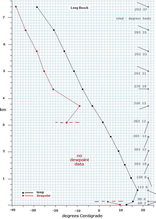
Fig.17. Long beach radiosonde profile, 1900 PST Dec 16 1953
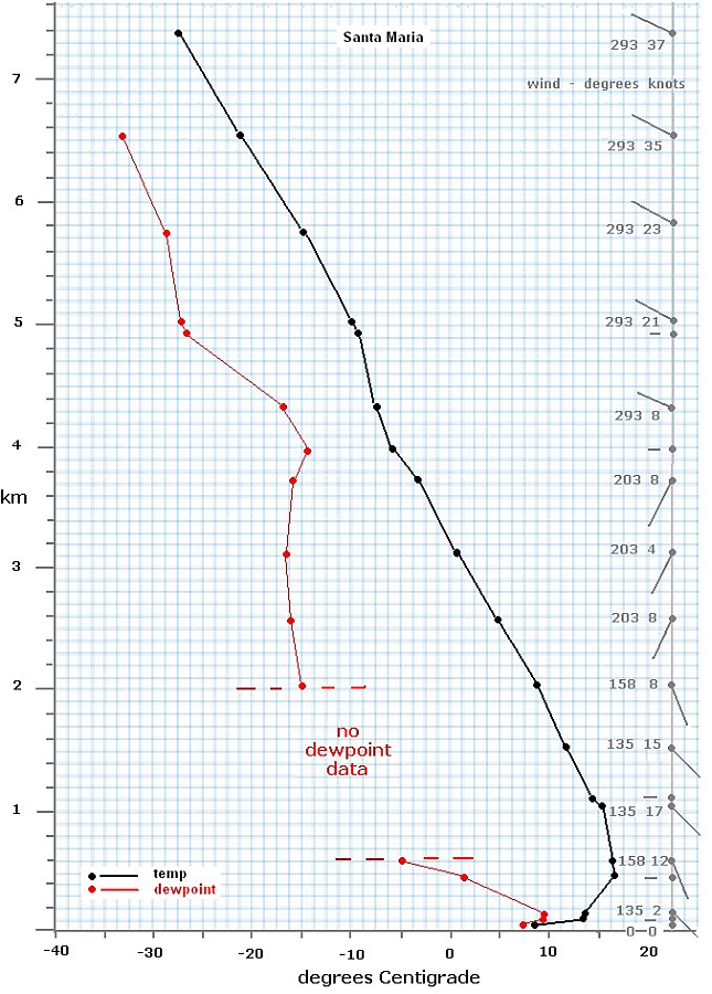
Fig.18. Santa Maria radiosonde profile, 1900 PST Dec 16 1953
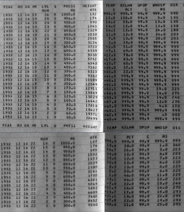
Fig.19. Computer print-outs of San Nicholas Island radiosonde
ascents, 1500 & 2200 PST, Dec.16 1953. 66
This island location is fifty miles or more from the sighting location in the
bay area, but the fragmentary wind data tend to confirm a pattern of variable low
level winds overlain by a southwesterly airflow rotating through
westerly with altitude, with average lapse rates between ~5.8ºC/km
and 6.0ºC/km (marginally conditionally unstable) over the two
ascents. Near the sighting level, wind is ~30 kt from the West,
there is no temperature inversion (no stable layer), and RH
readings are below saturation.
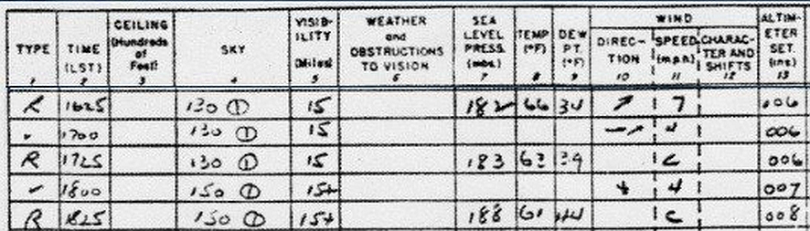
Fig. 20. Detail from surface weather obs, Los Angeles International Airport (LAX) 67
66 Credit: Joel Carpenter, email to the author 19.02.2013
67 ibid.
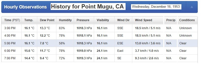
Tab. 4 Hourly surface weather observations at Point Mugu Naval Air Station for 2 hours either side of the sighting time 68
Lenticular or other cloud
The possibility that it was an unusually well-defined cloud is
known to have been considered at first by at least three of the
witnesses: Johnson (who specifically thought of a "lenticular
cloud"); Wimmer; and Thoren. All three said that they rapidly
discounted the possibility. Putting aside for a moment ambiguous
references to the object's motion (Section 6), reasons given were:
- the "distinct" and "definite" shape, "sharp edges" and
"sharp outline" of the object;
- the fact that it did not noticeably transmit or
forward-scatter any light at all from the setting sun, appearing
solid black (evidently in contrast to the cloud layers visible
where "the whole western sky was gold and red");
- the impression of complete changelessness for several
minutes;
- the fact that its outline remained sharp "right up to the
time it disappeared" so that "at all times it appeared as an
ellipse" and was "black and distinct" even as it shrank, and even
as viewed in 8-power binoculars.
Lenticular or lens-shaped clouds are a type of stationary wave
cloud distinguished by an often striking symmetry and smoothness.
They form when air is forced upward over an obstacle triggering a
standing wave in a shallow layer of statically stable air (i.e., an
inversion layer with no tendency for vertical circulation).
Adiabatic cooling of moist air in the wave peaks causes cloud to
condense here. The classic form is altocumulus standing
lenticularis.69
Lenticular clouds are physically and optically thin, having very
small droplet sizes because the droplets condense, migrate through
the wave, and evaporate without time for growth by collision and
aggregation into large drops. Because the cloud depends on
continual renewal it may dissipate quite rapidly in place due to
subsidence - a small reduction in the altitude of the wave relative
to the condensation level.70
Well-developed lenticulars are generally seen where strong winds
are deflected by high hills or mountain ranges (for which reason
they are also known as orographic, or mountain-formed clouds). In
the right conditions this forcing causes a layer of stable air to
oscillate, and like a harmonic mode of a twanged guitar string a
series of standing gravity waves extends downwind from the barrier.
The clouds form at altitude in the ascending moist air at the peaks
of the waves, whose amplitude in some cases can reach many
thousands of feet. This is often above the freezing level when they
are composed of supercooled droplets and/or ice particles. Such
mountain clouds are typically large, often linear ripple-like forms
miles wide, not always truly lenticular at all; but given the right
conditions of stability, localised forcing and sufficient wave
amplitude they can appear as isolated lens or almond shapes, and
where there are multiple stable layers they can resemble stacks of
elliptical plates with smooth surfaces and well-defined edges (Fig.
21).
An important distinction is made between vertically trapped lee waves, and untrapped or vertically-propagating lee waves. Gravity waves can only exist in statically stable air. The trapping occurs where a stable layer at the barrier crest is sandwiched between unstable airmasses which are unable to support gravity waves. It is these trapped waves in a sandwiched stable layer whose signature, when wave amplitude is high, is the lenticular cloud proper. They are also characterised by a small vertical directional wind shear (i.e. little change in wind direction with height) and require an abrupt escarpment on the lee side of the barrier, the windward profile being relatively unimportant.71
70 But note the evidence from Clarence Johnson (Section 6) that the object was visibly rising as it disappeared.
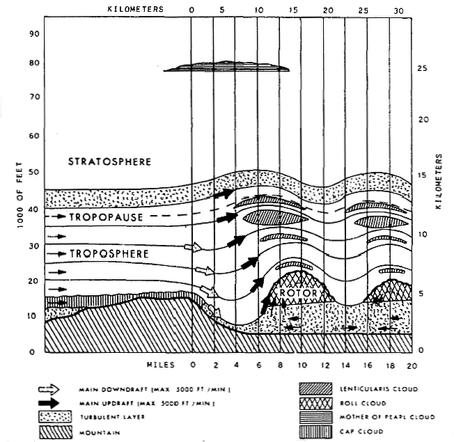
Fig.21. General structure of a mountain lee wave and its signature clouds 72
Untrapped waves, on the other hand, occur when the atmosphere is stable through a considerable depth and the waves are then free to propagate upward. They generally occur in the presence of marked wind shear aloft and are set off by broader mountain and hill ridges. The signature cloud of these waves is usually a less compact higher-altitude wave cloud called orographic cirrus.
Strong winds approaching Beaufort force 7 (moderate gale) in the stable layer are usually considered the minimum necessary for mature trapped lee wave clouds to form. A figure of at least 20 knots (37 km/hr) at the top of the barrier is widely cited. A UK Met Office source gives 20 kt and 300m (1000ft) vertical barrier height as the minimum conditions for trapped waves.73 A study in New Zealand indicated that winds in excess of 20-25 kt (37-46 km/hr) were required blowing at <30deg to the line of the orographic barrier.74
73 ibid
74 Alistair Reid, Mountain Waves & Clouds: Investigating the occurrence of cloud-producing mountain waves.
In the present case, in order to explain both sighting lines a cloud has to be above a position somewhere near Santa Cruz Island, and if there is evidence of strong winds blowing in a layer of stable air at around 2000ft (600m), with the lifted condensation level above, then a lenticular cloud could have plumed downwind of the island, perhaps above Anacapa, fitting the triangulated location in Fig. 2 quite nicely.
The 1900 PST Long Beach and Santa Maria radiosondes show a low-level inversion below about 500 - 600m, and an inversion layer is the definition of stable air. Limited data for Dec 16 1953 from coastal weather stations suggest a lifted condensation level around 1000m,75 conceivably lower in the cooler air over the ocean, which could also fit the wave cloud hypothesis.
But we have no evidence of strong westerlies, or any strong winds, near the mountain level (see Section 3). Wind was variable through the first few thousand feet, generally SE and averaging only about 10 kt or less at the barrier height. In any case the hypothetical lenticular cannot be in this level, where it would fit neither observation (being not even visible to the Johnsons from Agoura because of the mountain horizon). We need an extremely well-defined lenticular at or above 17,000 ft; and given a) the low-speed windflow over a relatively low island barrier, and b) no evidence of a stable layer around 17,000 ft that might support high-amplitude waves anyway, this seems highly improbable.
As already mentioned, it is now recognised that relatively low topography can have effects that travel to great heights via vertically untrapped waves in a very deep stable layer, producing the typical or signature cloud of orographic cirrus. But orographic cirrus is not the type of cloud we want, and untrapped vertical propagation through such a deep stable layer is not the process we want - since it will not produce a well-defined isolated lenticularis of this type. In any case, above the low-level inversion already discussed the radiosondes indicate a conditionally unstable state throughout the depth of atmosphere of interest, not a deep stable layer.
75 http://www.physics.usyd.edu.au/pdfs/current/2002projects/Reid_MountainWavesClouds.ppt
The lifted condensation level (LCL) is the height H at which an air parcel of a given constant moisture and heat content will become saturated due to adiabatic expansion-cooling when mechanically lifted. Mean and max Temperature and mean Relative Humidity are known for Longbeach Airport (Table 3). Dewpoint
Td is given by
where:a and b are constants,
T is ºC, and
RH is % (
http://einstein.atmos.colostate.edu/~mcnoldy/Humidity.html) giving dewpoints for
mean T and
maxT respectively of 6.77ºC and 11.7ºC. LCL is then given by inserting temperature and dewpoint into the following formula:
where
T and
Td are respectively temperature and dewpoint (Pettersen, S.,
Introduction to Meteorology, McGraw-Hill 1958). Or approximately
leading to values of
H at Longbeach for
mean T and
maxT respectively of 1084m and 1128m.
What we need is a shallow (thin) stable elevated layer supporting trapped waves, and in this case
the lenticular shape-definition is proportional to the amplitude, which is in turn proportional to the barrier height and the wind speed.
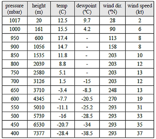
Table 4 Long Beach radiosonde 0300 Z, 17 Dec 1953 (1900 PST 16 Dec).
As discussed in the previous Section, although there is no hint of an inversion the balloon soundings cannot rule out a narrow, sharp layer falling between the samples. However, assuming that such a layer did exist near 17,000ft, how might it support the trapped high-amplitude waves needed for a well-defined lenticularis, decoupled as it is from topographical forcing by the deep sandwich of conditionally unstable air below it?
Absence of a topographical trigger does not mean that wave cloud cannot occur. Even in a high region of the free atmosphere, completely decoupled from any effects in the boundary layer, forced uplift and wind shear in a stable layer can trigger wave cloud. Uplift might be caused for example by air moving across the regular rows of "cloud streets", or by a wedge of frontal air moving under a layer of moist air, cooling and condensing it. Or advection of warmer air from the land over the top of cool sea air might create a stable inversion; and a wind shear through this layer might set off a gravity wave condensing some wave clouds. But there is wave cloud, and there is wave cloud. Because it occurs in stable layers of wide horizontal extent, and equally is triggered by lift or shear processes also having wide horizontal extent, most often high altitude wave cloud is stratified, a pattern of cloud over an area similar to orographic cirrus, or perhaps transient patches. But we need to account for one perfectly-defined lenticularis in splendid isolation, one which would do credit to the best high-amplitude mountain lee wave. This surely needs some strong local forcing.
Another possibility is that a column of rising moist air, such as occurs in a towering cumulus, might push into a stable inversion, where there is a strong wind shear through the boundary of the layer, triggering a standing lenticularis. But not only is there no recorded inversion at or near the appropriate level, neither is there any mention of towering clouds nor any suggestion in the reports or in the weather data that this type of vertical circulation was at all likely.
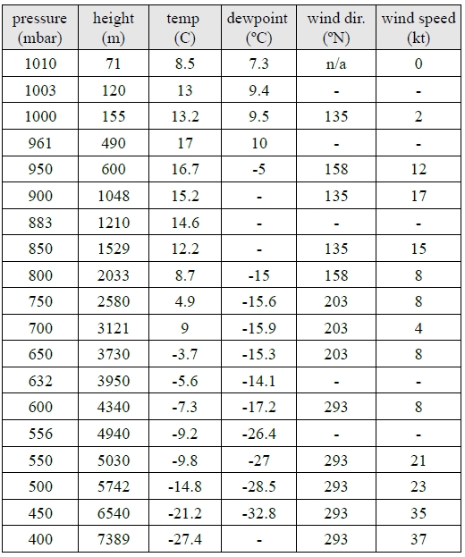
Table 5 Santa Maria radiosonde 0300 Z, 17 Dec 1953 (1900 PST 16 Dec) 76
To expand that point: Average lapse rates (above the capped marine layer) of 6.7ºC/km and 6.8ºC/km at Long Beach and Santa Maria respectively are only a degree or so higher than the moist adiabatic lapse rate of 5.8ºC/km (3.2ºF/1000 ft) indicating an atmosphere that, whilst not stable, is not unstable either, rather it is barely conditionally unstable. San Nicholas Island is also just barely above the moist rate (Fig. 19). In other words this is an atmosphere with little or no long-range activity, no untrapped gravity waves, no deep thermal currents either - meteorological vanilla. The scattered clouds within it (specifically around 14,000ft, evidently associated with the warming dew point near this level on the coastal radiosondes) give evidence of a slight degree of lifting and cooling in the conditionally unstable air, but this is certainly not the sort of strong convective mixing through a deep layer that causes clouds with a lot of vertical development, for which we require a lapse rate greater than the dry adiabatic lapse rate of 9.8ºC/km (5.5ºF/1000 ft), and no cumulus towers or other signs of warm upwelling in the clouds were reported. Upwind, the air was "extremely clear" above the scattered mid-level stratus, with the object "well out in the clear air" and isolated against a bright post-sunset sky.
And we should not forget that whatever this was, it was not one of many patches of wave cloud in a sky full of wave clouds, neither was it merely a nebulous wisp of wave cloud. We would have to say that it was not merely a text-book standing lenticularis but a remarkable exemplar of the type, so stable in form, so compact, dense, and sharp in definition that even observers including aviators and aerodynamicists familiar with mountain-forced lenticular clouds, several of whom initially thought it was a cloud, were disabused of that opinion after several minutes' careful observation with naked eye and binoculars.
The same evidence is also a problem for non-wave cloud theories. The most attractive might be a pileus cloud, a type of cap cloud above a rising cumulus which pushes up and condenses a moist layer above it. A related convection effect occurs when a cumulus congestus (towering cumulus) or altocumulus castellatus is driven by vertical convection to actually punch through a stable inversion. In these circumstances there is a column of moist air surrounded by dry air and the part of the column inside the layer experiences mixing faster than the parts above and below the layer, and this causes a "neck" to form. Eventually the neck dissipates and contracts to the point where it is cut and the upper part of the tower separates (Fig.22). Cut off (literally) from the moist circulation below, the separated "head" then begins to dissipate and soon disappears.
Fig.22 "Stages in the disintegration of a cumulus castellatus cloud"
(adapted from 77)
The first difficulty is that upper winds of 20 - 30 kt which would have been a positive for the standing wave cloud theory now become a negative for a convective model. Wave cloud can dissipate in place whilst remaining compact, but for convective cloud of the type considered here the process is messier. Dissipation occurs by thermal mixing, or by precipitating out, and there is no mechanism to keep the cut-off remnant of cloud compact and static in this strong airflow. It could not have been anything like so well defined as a lenticular in the first place, of course, and during mixing a process of
'entrainment' causes the dry air to soften the cloud so that its edges become increasingly wispy.78 Such a cloud would simply be diffused and blown away in tatters rather than contract compactly in place.79
77 Nias, J., 'On the Dissipation of Tall Cumulus Clouds', Monthly Weather Review, Vol. 67, No.8 Aug.1939 pp.294-6
79 Note that the freezing level was about 10,000ft. At 17,000 ft it was -11ºC, therefore any cloud would have been composed of a mixture of supercooled water droplets and ice crystals. A proportion of ice is especially likely for the non-wave cloud, since the larger droplets of which it is composed are less likely than wave cloud droplets to remain liquid (the smallest droplets can be supercooled down to -30ºC without freezing). Such a mixed phase cloud is not likely to dissipate so rapidly as a similar water-droplet cloud at low level, either adiabatically or by thermal mixing. Another factor is that in general ice clouds tend to have wispier, less well-defined edges than water clouds in the first place.
(
http://www.windows2universe.org/earth/Atmosphere/clouds/cloud_heights.html)
Finally, we come back to the dual facts that a) there is no evidence of a stable elevated inversion at the appropriate level to snip the top of a cumulus castellatus/congestus, and b) that the measured environmental lapse rate and the observed weather and cloud forms are inconsistent with unstable vertical circulation and towering cloud of this type.
Notwithstanding all of the aforegoing, what can be said about the likelihood that the observers would have failed to identify a lenticular cloud (if there was one)? One writer favouring the cloud theory, Lance Moody, has suggested 80 that the reported sharp definition of the object's outline might be explained as an illusion of great distance, together with the effect of being seen in back-lit silhouette against a bright sunset sky. It is a good point. Qualitatively, it is easy to understand that a large cloud that would appear very nebulous at close range can appear quite sharp if seen on the skyline at great distance, the more so in conditions of high visual contrast. Everyone who has watched sunsets is probably familiar with this effect. The triangulation means that this hypothetical cloud was not very large and very distant, but then a lenticular could be well-defined to start with.
81 The author knows of no model of cloud "fuzziness" that might help here. But let's grope towards a gross approximation in hope that we might learn something. Most of us don't see lenticular clouds all the time, but we are familiar with fair-weather convective cumulus looking quite solid against the sunset. Fair-weather cumuli range in size from nebulous wisps tens of metres across to mature clouds several km across. They tend to be smaller and more numerous in the morning, larger and fewer towards evening, and it is the larger mature clouds that have the greatest optical thickness and appear best defined (cumulonimbus tops look even more solid because of their scale). Typical mature cumuli are in the order of 1km across. (Plank, Vernon, G., '
The Size Distribution of Cumulus Clouds in Representative Florida Populations',
Journ. of Applied Met., Vol. 8. Feb. 1969, p.46; R.A.J. Neggers
et al.,
'The Size Statistics of Cumulus Cloud Populations in Large-Eddy Simulations',
Journ. of Atmos. Sci., Vol 60, Apr 2003, p.1060 ).
Now there are many photographs of cumulus clouds, variously lit, available to inspect on Google Images. One forms a subjective impression of edge density which may have at least some order-of-magnitude validity. How steep
is the transition from dark silhouette to clear sky in typical sunset shots? I think it would be reasonable to say that this "fuzzy" edge zone is commonly narrower than 0.1 diameter but rarely so narrow as 0.001 diameter. Let's say that for sizeable clouds a "sharp" edge is in the order of 0.01 diameter (equivalent to only 1mm on a 10cm-diameter image). For a 1km cloud this fuzziness would correspond to a layer of vapour in the order of only 10m depth around the cloud periphery.
That seems plausible for a rather well-defined large cumulus; less so for a small one. Small ones are much more characterised by nebulosity, in the limit of course becoming entirely nebulous. And we are interested in a small cloud in the order of only 100m across. For a small patch of cumulus only 100m across a 1%-of-diameter nebulosity would be an extraordinary degree of definition, in my opinion. But if we are looking at a lenticular wave cloud things are different.
Cumuli have no boundary to prevent entrainment (dissipation by thermal and mechanical mixing), but lenticulars, being constrained by, in particular, the relatively sharp upper boundary of the stable layer in which they
form, can be much more sharply defined - as inspection of photographs clearly shows. Of course it is true that 100m
is a very small diameter for a lenticular cloud, too, and the same scale argument applies even if to a lesser degree; also the conditions for an extremely well-defined lenticular are probably not met in the sighting conditions, as we have seen; nevertheless, let's allow that a 1% fuzziness is a good model for our hypothetical wave cloud. Then, at what distance does 1m of fuzziness subtend 1 arcmin, reaching the limit of resolution acuity for an average unaided eye and becoming effectively a sharp line?
The answer is in the order of 10 miles. This is the correct order for our purposes, implying that our model cloud might easily have looked like a sharp-edged solid to the naked eye. But there are other factors to consider,
circumstantial and meteorological.
Johnson was using 8-power binoculars, observing that "even in the glasses it appeared black and distinct" to the end - i.e., even when the cloud had shrunk (ex hypothesi) to 1/2, 1/4, 1/10 of its initial diameter - and this makes a large difference. Rounding to order-of-magnitude as before, it implies that a more comfortable distance would be in the order of 100 miles.
And it is important to remember that we are not dealing with a classically well-developed lee-wave lenticular of the type we see most often in photographs, often miles wide and shaped by a high-amplitude wave triggered by a mountain barrier; rather we are dealing with a cloud caused by less dynamic wave processes high in the free air, and of extremely small size. And in this situation size does matter because it is related to the opacity or optical thickness of the cloud. (cont. over)
Is it possible to test this at least semi-quantitatively? Probably not realistically81 but we can have some confidence in the approximate triangulated object location established in Fig. 2,82 and a simple way of thinking about it is to remember that 8-power binoculars brought this hypothetical cloud within an effective range of 5 miles from Johnson (which is half the real distance to the mountain over which the "lenticular cloud" at first appeared to Johnson to be) with an implied naked-eye angular size of almost 0.5º and therefore an initial effective binocular size of 4º (8 times the naked-eye diameter of the full moon, reducing to zero over 90 seconds). Frankly this is a rather large visual object (though a small physical object, in cloud terms) and it is somewhat impressive that Clarence Johnson could see no sign of the softening edges or churning activity that would have identified a cloud, especially during the process of dissipation which (ex hypothesi) he observed continuously for a minute and a half in the binoculars. We cannot conclude anything very definite from this, but at least it helps to give a feeling for the significance of Johnson's conviction that he was not watching a cloud.
But when it comes to clouds, did Johnson really know what he was talking about? On the basis of Johnson's statement that he abandoned the theory of a lenticular cloud when the object "did not move at all" Lance Moody has proposed that Johnson didn't understand lenticular clouds. He reasons83 that Johnson is especially impressed by the bulk-stationarity of the object, and since stationarity with respect to the landscape is a characteristic of a mountain-wave lenticular (though not necessarily of other types of wave cloud which do not have to be anchored to topography, as we have already seen) Moody thinks that Johnson must be ignorant of how wave clouds behave, making him a naive observer whose impressions ought not to carry much weight. But this calls for a dose of realism.
(cont. from p.51)
There is one figure which is quite eloquent: On average, the photon free path length inside a water cloud - i.e. the distance a photon penetrates before it is scattered once by a droplet - is in the range 10 - 200m, call it order of 100m (A. Kokhanovsky, '
Optical properties of terrestrial clouds', Earth-Science Reviews 64 (2004) 189- 241). Obviously less than one scattering (zero scattering) is complete transparency. The diameter of our hypothetical cloud (assuming a discoid) was in the order 100m. Even at its centreline (point of maximum geometrical thickness) such a cloud would on average be only one scattering event away from being optically transparent. Granted a lenticular cloud is probably optically thicker per unit geometrical thickness than, say, a cumulus, because a wave cloud consists of small transient droplets of uniform size that do not coalesce. Basically it is a mist, and mists tend to have a larger numerical density of smaller droplets, and therefore shorter free path lengths, than clouds with larger droplets (
ibid.). Even so, a wave cloud of this small diameter should be optically thin, especially as you go out along a radius towards the perimeter with geometrical thickness reducing, so the chance of a sharp-edged black silhouette seems small even at the start of the observation, and dwindles even as the object itself appeared to.
Brad Sparks (emails, July 02/04 2014) reports having made many observations of "small" clouds against the winter sunset from this part of the California coast to test the theory, finding that in all cases they appeared grey
(transmitting light) and fuzzy, indeed often light-haloed. He has never seen one that appeared black or sharp-edged.
He notes that photographs with high contrast can look dramatic but do not represent real-world conditions.
Perhaps it is fair to say this: It is not obvious, when thought about, that Johnson should have failed to discern the nebulosity of a cloud in the circumstances. Of course that is not to say it is impossible.
82 The presentation of the lenticular cloud theory by Lance Moody (
http://www.notaghost.com/2012/03/a-prosaic-
explanation-for-a-famous-ufo-case.html) includes a graphic from another forum purporting to show that the object location is wildly uncertain by 30º of bearing and hundreds of miles distance. This is an artefact of confusing the very clearly referenced "Santa Barbara Islands" with little Santa Barbara Island about 50 mi away between Catalina and San Nicholas (see Fig.2 & Note 19, p.12). Another point worth mentioning about Moody's treatment is his claim that a UK meteorologist on a weather forum diagnosed the radiosonde data as showing that "conditions were ripe for the formation of lenticular clouds". This considerably misrepresents the position. One forecaster on the forum (
http://www.ukweatherworld.co.uk/forum/index.php?/topic/89414-interpretation-of-historic-radiosonde-data-help-wanted/page__p__787469#entry787469)
suggested that there may have been a hint of warm advection near 600hpa (4300m; 14,000ft) where lifting and wind veer "may" have been able to cause "at least some wave phenomena"; two other members doubted that conditions were right for a lenticular cloud. But firstly the moist pinch-point of RH around 13-14,000ft (4000m) corresponds to the scattered cloud layer through which Wimmer climbed at "about 14,000 feet" several minutes before the object was sighted, and this takes care of the lifted condensation going on at this level; secondly, 14,000ft is too low, in the absence of a trigger forcing an implausible wave amplitude reaching 3000 ft above this level, because the object was at or above the WV-2 altitude when climbing through ~17,000 ft (see Sect. 3, p.12); and thirdly, in any case a chance of "some wave phenomena" does not really account for a superbly-defined isolated lenticular of the type implied (see discussion above, p.45, Section 7)
The physics of lee waves is pure aerodynamic flow, the same physics that governs the flow of air over a wing aerofoil, and a lenticular cloud is a natural aerodynamic condensation trail of precisely the same type that occurs in the flow over the lifting surfaces of high-performance aircraft. Wave flow and turbulence are bread and butter for aircraft designers, and for pilots, and Johnson was both. He was employed in the roles of flight test engineer, stress analyst, aerodynamicist and others before becoming Lockheed's chief research engineer in 1938.84 There were very probably no other people in California that day (indeed very few people in the world) as qualified by expertise, talent and experience to understand streamline flow as was Clarence Johnson. By 1952 he was well on the way to acquiring the status of a legend in the industry, widely regarded as an aeronautical genius, recipient of dozens of national and international honours and awards, responsible for some of the most famous aircraft innovations in history. Johnson's boss at Lockheed Corporation, Hal Hibbard, once remarked of him to his Skunk Works successor, Ben Rich: "That damned Swede can actually see air."85
So the reason that Johnson thought "lenticular cloud" was not that he happened to have read an article about them in the 1953 equivalent of the Huffington Post, but because as an expert aerodynamicist and the world's top aeronautical design engineer he would have had a professional need to understand such phenomena of the atmosphere - phenomena which, be it noted, are of real practical concern to pilots who make a point of knowing all about them because of the dangers of downdrafts in lee waves.
Let's look more realistically at what Johnson said in his short account. He tells us that several thin layers of moving cloud or haze were visible against the sunset sky, "coming onshore" on a westerly wind. At first he assumed that the black object was an unusually dense but ordinary cloud, then an "intense smoke trail", and then after realising that there was no change in its shape or appearance he decided that it was "a lenticular cloud". During this time it did not bodily move, and stayed "above a mountain". These are all good observational clues to a lenticular.
But he changed his mind. Why? In his account, he gives the impression that he was already sure it was not a cloud before he got the binoculars on it and before it began to to "move behind" one of the "layers of thin cloud or haze at fairly high altitude" (i.e., before he had decided that it was not really hanging "above the mountain" like a lenticular but was much higher and more distant and moving fast). This may or may not accurately reflect the sequence of his thoughts in those few minutes; but in saying that the "outline of the object did not change . . . it did not move at all . . . it did not move or disintegrate" he is not referring only to an absence of bulk displacement.
A lenticular cloud is actually a very dynamic cloud. It is continually in seething internal motion, condensing and evaporating, with droplets rushing through it from front to back. Observed carefully, it frequently has a churning tail or halo of vapour, or shreds of wave cloud forming and dissolving around it. And although a lenticular may not drift laterally very much it is not by any means the case that a lenticular is required to sit perfectly still. It is slaved to the wavelength and amplitude of the wave, like a kite on an elastic string, and it may be subject to changes in height and outline and density on short timescales as the standing wave on the stable layer resonates like a plucked string under the influence of the wind. If the wave trigger is perfectly static (i.e. a mountain), and if the stable layer itself is not subject to uplift or subsidence, and if the wind speed at the level of the layer is constant, then the cloud might seem totally unchanging to a casual observer. But in the real world a careful observer would expect that he might be able to detect a certain amount of internal/peripheral turbulence as well as small bulk motion - this is especially the case with a high-altitude wave cloud that is not tied to topography but is subject to fuzzier weather processes.
And after all, ex hypothesi this cloud has to dissipate rapidly, which typically occurs precisely because of downward motion bringing the wave altitude below the condensation level.86 But in several minutes of careful observation, including a period with 8x magnification binoculars, Johnson saw no peripheral or internal motion, and no sign of bulk motion. Finally of course he did see apparent bulk motion when it appeared to climb - opposite to the subsidence that would be expected if it were a dissipating cloud - and to "move fast" (whether to some extent transversely or purely radially remains unclear; see Section 6) into the distance.
8. Conclusions
In Section 7 we considered the possibility that the object was a large conventional plane, but for several reasons (including extended hover for several minutes and implied size) this is unworkable. A very large Lighter Than Air vehicle could not disappear rapidly. The initially attractive theory of mirage is also unworkable for several reasons, both meteorological-optical and geometrical. There is neither a common raypath nor a common set of atmospheric conditions on lines of sight separated by ~40 miles of linear distance, ~15,000ft of altitude and ~40º of azimuth angle. We could try to rescue the theory partially by assuming that one set of observers saw a mirage whilst the other saw (say) a lenticular cloud, or that they saw two quite different clouds. But different explanations of two similar and simultaneous observations would be uneconomical and inelegant
.
All evidence seems consistent with the conclusion that a physical object or phenomenon of some sort remained near-stationary for several minutes at about 17,000 ft, located at the crossing point of two lines of sight (some 40º away from one another) approximately over Anacapa Island. The next most important question is: Did it then move away rapidly or remain stationary while dwindling in size? Unfortunately we have not found a conclusive answer to this question.
There is room to interpret the reports as implying some lateral angular motion, but neither group unambiguously reports lateral motion.87 However, as discussed in Section 6, it is possible to interpret Johnson's report as indicating some lateral motion. This is far from being clear enough to take to the bank, but we can make a reasonable case which is at least no more ambiguous than its opposite. And we concede that such lateral motion as might be implied would be in the correct direction to at least qualitatively reconcile the angle between lines of sight.88
Or perhaps the explanation is that the actual course of the object's recession bisected the angle between the two sighting lines, minimising the azimuth rate for both observer groups? Again we could make a case:
Johnson was on terra firma, could fix his bearing(s) by reference to certain local landmarks, was in a position to brace himself against a window or wall if necessary, and trained 8x binoculars on the object for 90 seconds. So we would expect that Johnson was relatively well-placed to detect small angular motions. But he interrupted his naked-eye viewing and changed location by going outside, resuming observation in the narrow FOV of the binoculars even as the object already seemed to be moving. Destroying continuity in this way would make bearing judgements less sure, and might also help explain ambiguity in the "heading" figures that Johnson reported.
86 Note once again that Johnson saw the object appear to "climb" as it disappeared, not descend
87 There is somewhat convincing evidence of small angular vertical motion seen by Johnson on the ground, but not noticed by those in the air.
88 As mentioned in Section 6, even if no lateral motion at all was observed by either group these facts could still
possibly be consistent with two triangulated sightings of a mobile object receding westward on a course with a dogleg of approximately 40° but it is not clear that this scenario can be made to work in quantitive detail, and an argument for such fortuitous timing has the ring of special pleading about it.
Meanwhile the WV-2 crew were on a moving plane over the partly-beclouded ocean, orientated mainly by magnetic compass and, of course, by the object itself during their pursuit of it. They recalled flying directly towards the object whilst it disappeared. So might it be that a small tracking correction in their course concealed a lateral drift of the receding object during the minute or so of its disappearance? The total observable displacement for the WV-2 observers, viewing it with the naked eye, need be only a few degrees, arguably a negligible amount of left-rudder, and an absence of fixed seamarks due to underlying stratus could have helped to make such a slight turning motion difficult to detect.
But of course, "saving" the witness impressions of a moving solid body does not help us to explain the object without some highly uneconomical assumptions.
On the other hand, the contrary interpretation of a static body does not help all that much either. The only conventional explanation having even a little plausibility is an unusually compact and well- defined lenticular wave cloud. But given circumstances and conditions known and inferable it has to be said that such a cloud seems unlikely; and most importantly, it seems unlikely that such a cloud would dwindle in the shape- and sharpness-preserving manner described.
Visual evidence
Which brings us to the reliability of the descriptions. In evidence we can mention that the witnesses had technical expertise of a certain relevance, that they all had wide experience with things in the air, and that they all began with presumptions of ordinariness, typified by Johnson's escalation of hypotheses through "cloud" to "intense smoke trail" to
"lenticular" to "saucer". An awareness on Johnson's part that this was not a trivial conclusion is indicated by his reluctance to be associated with reporting a UFO through the usual channels, as attested by General Putt in his cover letter to ATIC dated February 15 1954 (see Appendix).
But there is the issue of previous sightings: Johnson is not shy to admit (in official confidence) that one night around Christmas 1951 he had seen a fast-moving "flame or emanation" of a "beautiful light blue" colour near Brents Junction, California, which he believed to have been a "flying saucer" (a phrase he does not care to define). He assumed that the light was trailing from some object but did not see any object. In a similar time frame Wimmer and another Lockheed employee had, according to Ware, seen some "lights" that "stood still for a while and moved around" over Catalina Island. And Ware himself had seen an odd object in the evening sky from his home, again around Christmas 1951, but this did not stop him joining in with the others who had "kidded Roy [Wimmer] a good deal" on account of his own sighting, presumably including Thoren who considered himself to have been "very skeptical" before Dec 16 1953.
Do these sightings suggest a prior tendency to misinterpret or imagine things? No. To characterise a witness as a repeater on the basis of one recollected past sighting would be unreasonable. Pilots and others who look at the sky every day will tend to notice odd things and swap their stories, and in a saucer-aware culture (of course in the early '50s there was a very different climate of opinion about these things) the sightings will tend to acquire this label. None of these sightings is of high strangeness, none was actually reported as a UFO at the time, and it is possible to imagine that they might be explained as unusual but conventional phenomena if we had some detailed information. Typically in such cases it is found that the overt and latent information reported by rational and sincere witness contains the cues serving to identify the cause, and there is no reason to think this would not prove true in these cases. They cannot be used as evidence that Johnson, Wimmer and Ware were less than typically reliable observers.
At the same time, of course, typically reliable observers are known to be rather fallible. And there are important questions remaining unanswered.
If the object was so remarkable why was it not seen by other observers on the ground who were closer than were the Johnsons at Agoura - say, on the coast, or on the islands? Seen from below it would have been a large object several times the apparent size of the moon, even at 17,000ft. Perhaps the absence of other reports implies that it looked mysterious only from a great distance and/or to observers whose positions happened to place it in stark silhouette against the sunset. Perhaps closer observers who noticed it higher in the sky could see that it was only an unusual cloud and didn't bother to report it.
Of course the situation of being backlit in silhouette would not only make a cloud more striking; it would enhance the prominence of any opaque body, including a "saucer", perhaps favouring observers who were distant enough or high enough to see it at low angular elevation against the sunset. One could argue that relatively few people were in such a position: Clarence Johnson and his wife saw it because they had a rare view over the tops of the coastal mountains from their luxury hilltop house, and happened to have binoculars available; the others saw it because they happened to be airborne in the WV-2 at the time. Both groups had a natural awareness of phenomena in the sky and were unusually motivated - professionally and personally - to pay attention to them.
There must have been many potential observers much nearer. But seen from below, a partly-sunlit object, of unknown hue and reflectivity, seen in plan against the dusky sky overhead, could have much less optical contrast and would tend to be a less striking sight. Moreover the view of an observer below may have been interrupted by the broken cloud layers over the sea. In any case, a casual observer is probably less likely to be looking at the zenith than at the spectacular sunset on the horizon. And whatever it was, we have reason to think that it was only there for a matter of minutes.89 So this works both ways.
Still, this is a populous coast. If a truly strange, large object had really hovered near the triangulated position, is it not a strange coincidence that only these Lockheed employees happened to see it? Again, not necessarily, because the group was
self-selected via its members' common connection to the Air Force through the WV-2 contract office and General Putt. Had it not been for this confidential back-door route into Project Blue Book where Johnson's discreet report ended up we would probably not know that anyone had seen anything. Individually, it is likely that none of these people would have gone to the newspapers, for example, or filled in a UFO report through the usual channels. The same could be true of others.
Certainly the Air Force appears to have showed no interest whatsoever in pursuing further inquiries. The Blue Book file consists solely of Johnson's report in its original form, as forwarded by Putt, and even part of that (Ware's map) is missing. There is no comment or analysis, no record of any attempt to interview or investigate. There is no evidence that anyone sent out a single memo or picked up a telephone. The only official document is the file record card, bearing the terse evaluation "cloud".90
89 Note that when the WV-2 itself was closest to the LOS-cross position at about 1635-1639 when approaching its first turn over the sea (near point 2, Fig 2) the crew had seen nothing.
90 Brad Sparks points out (email to the author, July 02 2014) that Blue Book may have investigated, but papers may have been removed from the file. Many files from this period are missing documents other than original telexes and record cards, possibly because of overzealous housekeeping. Also Dec 1953 was the month when Air Defence Command's 4602nd Air Intelligence Service Squadron took over first-response investigation of domestic reports. The AISS was not obliged to forward evidence and investigation material to BB on "closed" (identified) cases, only to "furnish information" on its conclusion. So it is possible that years after the fact BB disposed of paperwork deemed inessential on the assumption that records were preserved by AISS, although in this case the report reached Blue Book directly via General Putt and may never have gone through AISS at all. In any case this would be difficult to prove. See also p.58.
Howsoever, the bottom line is that many other people could have seen and reported the same UFO through various media. As far as we know, none did.
Radar evidence
There is none. But the question is: Ought there to be? If so, is Blue Book's lassitude enough to explain why there is no record of radar detection of a huge UFO over the Channel Islands?
There was an Air Defence Command surveillance radar right there on Santa Rosa Island, not 30 miles from the approximate LOS-cross point over the Anacapa area. Santa Rosa Air Force Station91 had opened in 1950 during the Korean War as part of the US permanent radar defence net and by 1953 it operated FPS-10 radar (basically General Electric CPS-6B with some minor modifications 92) which incorporated a height-finder and had range/height coverage of about 165 miles up to 45,000 ft.93 The UFO would have been comfortably within Santa Rosa AFS coverage. It would also have been within the coverage of another defence radar site located further away at San Clemente Island AFS, about 85 miles SE of the location, operating FPS-3/4 radars.94 If anything was detected, surely it ought to have found its way to the Air Force file given the circumstances and the status of the witnesses.
Perhaps the issue is not quite so simple: detecting is not the same as observing, and observing is not the same as reporting. For example: a detection, or single "blip", can occur without being noticed; or a single blip can be noticed without being seen as part of a "track" for various reasons; and a track can be observed without being reported. These are real practical issues.
Consider that the FPS-10 has variable rotation rates between 2 and 15 rpm, meaning that when operating at its most "alert" it has the chance to "look" in the right place every 4 sec., but if running in its routine slow peacetime mode (which it would normally do, since this uses less power, causes less wear on antenna shaft bearings, and maximises efficiency with long-range targets - the priority of a "picket" radar) it would only get a "look" every 30 seconds. In other words during the 5-minute sighting an object might have been detectable on as few as 10 sweeps of the radar in total.
And then there is another factor. Many surveillance and search radars use Moving Target Indication, a technique developed in WWII for cancelling echoes from the ground to improve visibility of moving targets. Both the San Clemente FPS-3 and the Santa Rosa FPS-10 were fitted with MTI.95 96 If MTI was in use, the echoes could have been rejected during the main stationary phase, leaving only the implied high-speed departure phase for possible detection. If this lasted 90 seconds from the start to invisibility (to use Johnson's figure) then the object could have appeared on possibly as few as 4 scans. It is possible that 4 widely-separated paints coming apparently out of nowhere might not even be noticed/connected by an operator. And if they were, there is no guarantee he would report a real target. It could easily be dismissed as AP or a noise track and any record of it could die at the base level. Even if it was logged as a genuine track, it may have been ignored because it was outbound, not inbound, and therefore irrelevant in terms of the radars' defence mission. Could they have assumed that it was a classified Navy missile or drone gone astray from the nearby Pt Mugu test area?
92 The original CPS-6 had shorter range and very poor height performance, limited to about 16,000 ft., which would give a very different complexion to this issue. But there appears to be no question that Santa Rosa AFS had the later 'B' variant and/or FPS-10.
Well, what about the Navy, then? The implied location would have been only about 20 miles from Pt Mugu, where the Navy had war-surplus SCR-58497 radars bought in for the off-shore weapons test range. These were anti-aircraft gun-laying radars built for the Army from 1943. They were van- mounted mobile tactical tracking radars mainly designed for providing AA fire control, and were well-suited for tracking experimental missiles in the Navy test range area off Pt Mugu, remaining in use until about the end of the decade when they were replaced by more sophisticated AN/FPS- 16s.98 But the SCR-584 could be used in a surveillance mode having a maximum PPI range of about 40 miles with good high-elevation cover and a scan rate of 5 rpm, so in principle a UFO hovering 20 miles off the coast could have been detected easily.
However somewhat the same qualifiers apply. The SCR-584 was certainly fitted with MTI to reject stationary target echoes, being indeed one of the first radars to use this clutter-suppression system developed by the MIT Radiation Laboratory in 1945.99 Moreover, as this radar was installed for missile test instrumentation (together with Askania cine-theodolites) there is no reason to suppose that it was being operated/monitored in a surveillance mode at the time of the incident, or that any radar was even manned.100
In any case, a report from a Navy installation would not necessarily get into the Blue Book system at all. Although on paper Blue Book was (I believe) responsible for reports from all service branches, in practice this was not true. The US Navy in particular was famously jealous of its own intelligence, most especially in this era,101 and to this day almost no naval incidents appear in the Blue Book files.
And when it comes to reporting, the same sort of issue applies to the Air Force air defence radar sites on the islands. These were operated by Air Defence Command, a separate body within the Air Force, identified by regulations as having its own "direct interest" in UFO reports. This interest was served by the creation in early 1953 of the ADC's 4602nd Air Intelligence Service Squadron (about the time that the CIA's Robertson Panel convened, changing the shape of Air Force UFO activities) which was charged by Air Force Regulation 200-2 with responsibility for handling military UFO reports prior to routing them to Project Blue Book. Many cases disappeared inside ADC. At the same time Blue Book was stripped of staff and resources and by the end of 1953 had become a wholly emasculated office.102 So it would not be very surprising if an ADC radar report that December never reached the file cabinet at Dayton.103 Indeed, we can see that the only reason we have any record of the sighting at all is because Johnson's report was innocently forwarded direct to Blue Book under the personal cover of a letter from General Putt.
Obviously none of these considerations alters the fact that we do not have any evidence of anything unusual having been detected on any radar in the area.
100 I have been unable to find out if they had a dedicated airfield surveillance radar to serve their one concrete airstrip in
1953 or if they used one of the 584s.
101 Navy photoanalysts had been humiliated by the rejection of their report on the Tremonton movie by the Air Force/CIA Robertson Panel earlier that year.
103 Note that Oxnard Air Force Base, north of Pt Mugu, was also operated by ADC, having been reactivated and assigned to ADC's 27th Air Division in 1951.
Final reflections
As so often the evidence is intriguing, ambiguous, incomplete, uncertain, and in the end it comes down to a costing of competing unlikelihoods. We have to resort to the essential subjectivity of tools like Occam's Razor.
On one hand, we can construct a conventional interpretation that looks quite plausible at first sight, and if it stayed plausible its economy would easily justify the cost of discounting certain report features; but it turns out to be very difficult to make it work meteorologically.
On the other hand, we could frame Johnson's "flying saucer" hypothesis in such a way as to work well without discounting any report features; but it would not necessarily be very elegant and it would incur an unknown cost that William of Occam would hesitate to pay.
It would be helpful if there were such exotic things as saucers, because a saucer (depending on properties) might well tick more analytical boxes in this case than does a cloud; but - and this is arguably the ufological Catch-22 in a nutshell - the report itself is not sufficient proof that exotic saucers do exist.
© Martin Shough, July 2014
APPENDIX : The Air Force file
WITNESS REPORTS AND COVERING LETTERS 104
|
Colonel George L. Wertenbaker
Commander
Air Technical Intelligence Center
Wright-Patterson Air Force Base, Ohio
Dear Colonel Wertenbaker:
I am enclosing a report, prepared by Clarence L. Johnson, Chief Engineer of Lockheed
Aircraft Corporation and some of his associates, regarding a “flying saucer” incident.
This report was handed to me by Lockheed personnel with the explanation that Mr. Johnson
was most reluctant to write the report in the first place and then refused to forward it
on to you because of his belief that those who profess to have seen flying saucers are
not usually considered to be logical and practical hard-headed engineers. However, I
thought you should have the report for whatever value it may be in your overall studies.
Best Regards.
Sincerely yours,
D.L. Putt
Lieutenant General, USAF
Commander
1 Incl:
Report
104 Scans of original documents may be seen here:
http://www.nicap.org/docs/lockufo3.pdf
This corrected text is based on transcriptions prepared by Lance Moody:
http://www.notaghost.com/2012/03/a-prosaic-explanation-for-a-famous-ufo-case.html
|
January 23 1954 LAC/149536
Subject: Sighting of Flying Saucer by Certain Lockheed Aircraft Corporation Personnel
To: Commander
Air Technical Intelligence Center
Wright Patterson Air Force Base, Ohio
Through:AFPR
Enclosure: (a) Four copies each of reports by C.L. Johnson, R.L. Thoren, R.L. Wimmer,
P.A. Colman, and J.F. Ware on the Sighting of a Flying Saucer on 16 December 1953.
1. The enclosure is made up of a number of reports concerning the sighting of a so called flying saucer on 16 December
1. The reports are self-explanatory. Only one copy of the map is attached,
indicating generally where this device was seen. This information has not been
released to the press, but is submitted for such scientific purposes as your group
may be concerned with.
2. Your comments on the sightings reported will be very much appreciated.
LOCKHEED AIRCRAFT CORPORATION
CALIFORNIA DIVISION
(SIGNATURE)
Clarence L. Johnson
Chief Engineer
CLJ:vmp
|
|
|
CALIFORNIA DIVISION
LOCKHEED AIRCRAFT CORPORATION
December 18, 1953
To: Air Force Investigating Group on Flying Saucers
On Wednesday, December 16th, 1953, my wife and I went to our ranch, which is three miles
west of Agoura, California, and one mile north of Ventura Blvd. We arrived there about
sundown, which is close to 4:45 P.M. PST. We went immediately to our ranch house, which
is located on a hill facing southwest.
At approximately 5 o’clock (within two minutes of accuracy), I was looking at the sunset
through a large plateglass window, when I noticed above a mountain to the west what I
first thought to be a black cloud. The sun had gone down and the whole western sky was
gold and red, with several thin layers of clouds or haze at fairly high altitude. I
wondered why this one object was so dark, considering that the sun was behind it. I
immediately thought that some aircraft had made an intense smoke trail, so I studied the
object closely. It was apparent, after my first few seconds of consideration, that the
outline of the object did not change. Thinking it was a lenticular cloud, I continued to
study it, but it did not move at all for three minutes. I do not know how long it was
there before my attention was called to it.
When it did not move or disintegrate, I asked my wife to get me our eight-power
binoculars, so I would not have to take my eyes off the object, which by now I had
recognized as a so-called “saucer”. As soon as I was given the glasses, I ran outside and started to focus the glasses on the object, which was now moving fast on a heading
between 240 and 260. When I got the glasses focused on the object, it was already
moving behind the first layer of haze. I gathered its speed was very high, because of the rate of fore-shortening of its major axis. The object, even in the glasses, appeared black and distinct, but I could make out no detail, as I was looking toward the setting sun, which was, of course, below the horizon at the time.
In 90 seconds from the time it started to move, the object had completely disappeared, in
a long shallow climb on the heading noted. The clouds were coming onshore, in a direction of travel opposite to that of the object. The time in which my wife and I studied this object was between 5:00 and 5:05. The object, which had hovered stationary for at least three minutes, appeared to be very large but, not knowing its distance from me, I could not estimate its dimensions. At all times the object appeared as an ellipse, with a finess [sic.] ratio105 of the larger axis to the minor one of about 7 or 10 to 1. I estimated the position of the object to be roughly over Point Mugu, which lies on a
bearing about 255˚ from my ranch.
On the morning of December 17th, I returned to work, having been absent for about a week
and Mr. Wassell, Assistant Chief Engineer, and Mr. Carl Haddon, our Chief Project
Engineer, came into my office with Mr. Rudy Thoren. Mr. Thoren stated that he had seen a flying saucer the day before. I immediately broke in, without letting him say what time and where he had seen the object, and described my experience of the night before. I wanted to do this so that I could get confirmation as to whether of not he saw the same
thing I saw at the time stated. Mr. Thoren was dumbfounded, and described his experience, along with that of our engineering test pilot, Mr. Roy Wimmer, flight engineer Joe Ware, and our chief aerodynamicist, P.A. Colman, all of whom saw the object as described in Mr. Thoren’s memo.
I should also state that about two years ago Mrs. Johnson and I saw an object which I
believed at the time, and still do, to be a saucer, flying west of Brents Junction,
California, on a very dark night. I did not see the object itself but saw a clearly
defined flame or emanation, as shown on the attached sketch. This object was travelling
from east to west at a very high speed and with no noise The flame or emanation was a
beautiful light blue, having extremely well defined edges. My first impression was that
it was an afterburning airplane, but the lack of noise and the pure spread of the flame
eliminated that possibility completely.
I should state that for at least five years I have definitely believed in the possibility
that flying saucers exist - this in spite of a good deal of kidding from my technical
associates. Having seen this particular object on December 16th, I am now more firmly
convinced than ever that such devices exist, and I have some highly technical converts in
this belief as of that date.
(SIGNATURE)
Clarence L. Johnson
Chief Engineer
CLJ:vmp
105 Johnson made a typographical error. This should read "fineness ratio".
|
FLYING SAUCER?
On Wednesday, December 16th I made a test flight in Constellation 4301. The crew in the
cockpit consisted of myself as pilot, R.L. Thoren as co-pilot, Charles Grugan, flight
engineer, and J.F. Ware as flight test engineer.
I took off late in the afternoon and ran some tests during the climb to 5,000 feet and
then made a level run for a few minutes.
I then started to climb to 20,000 feet and turned the controls over to Rudy Thoren. We
continued our climb in a south-easterly direction and somewhere in the vicinity of Long
Beach or Santa Ana between 16,000 and 20,000 feet we made a right turn onto a west
heading. The sun had just set but the air was very clear and the light was real good
toward the west. I noticed a cloud layer in the west starting somewhere east of Santa
Cruz island at about our altitude. Above this cloud layer, well out in the clear air, saw what I thought was a small cloud. Just for the fun of it I said, "Hey, look at the flying saucer!”
After watching it for a few minutes we decided that it wasn’t a cloud but some kind of
object. It had a definite shape which appeared to me like a crescent. Others on board described it as a huge flying wing. I could not detect any details other than the shape of it. I estimated the distance from us to be at least fifty or sixty miles and possibly much further. In the clear air like that it is very hard to judge distance. We flew directly toward it for about five minutes and our relative position did not appear to change. I do not recall our exact speed, whether we were still climbing or whether we had leveled off during the time.
As Rudy was flying the airplane, I had nothing else to do but to watch the object. After about five minutes I suddenly realized it was moving away from us heading straight west. In the space of about one minute it grew smaller and disappeared.
I was watching it all the time so I was able to see it for several seconds after the rest of the crew lost sight of it. Right up until the time it disappeared it maintained its sharp outline and definite shape so I know it was not a cloud that dissolved giving the appearance of moving away.
I might add that I have had considerable experience, while doing radar bombing on P2V’s,
of estimating distance where there is very little to judge by and I am convinced this was
a large object some distance away.
(SIGNATURE)
Roy Wimmer
Engineering Test Pilot
|
|
Lockheed Aircraft Corporation
California Division
INTERDEPARTMENTAL COMMUNICATION
To: Clarence L. Johnson Date January 11, 1954
From: P.A. Colman Dept. 72-23 Plant A-1 Ext. 8-2189
Subject: FLYING SAUCERS
This is an account of my experience of witnessing the presence of
an object in the sky. I was flying in the Lockheed WV-2 airplane
with Mr. R.L. Thoren, Mr.Joseph Ware, Mr. Roy Wimmer plus other
members of the Flight Test Group. The three individuals mentioned
and I were in the pilot's compartment of the airplane, at
approximately 5:00 p.m. on the night of Wednesday, December 16,
1953.
While flying off the coast in the vicinity of Santa Monica, I saw
an object apparently standing still in the air off the coast, in
the vicinity of Point Mugu. We were flying at 16,000 ft. and to the
best of my judgment the object was at the same altitude. The object
appeared as a thin black line, giving a first reaction of a B-36
type airplane, heading straight toward us and silhouetted against a
bright background. The background was bright due to the fact that
the sun was just setting. The object appeared not to move while we
progressed with our tests. For a few moments we turned the airplane
toward the object but did not apparently change our distance
sufficiently to get any change of impression. I estimate that the
object was hovering in out sight for about ten minutes. Thereafter,
it suddenly accelerated due west and in a time, in the order of 10
seconds, disappeared from view.
The following day it was revealed that Mr. Clarence L. Johnson had
seen the identical object while standing on the ground at his ranch.
This coincidence is interesting. The difference in the positions,
both horizontally and vertically between us indicate that the
object had sufficient depth to eliminate the possibility that it
was a cloud phenomena. The similarity of the explanations of the
shape and actions of the object is remarkable. However, the
blackness made it impossible to discern anything but the basic
outline.
(SIGNATURE)
P.A. Colman
Chief Aerodynamics Engineer
PAC:ma
|
FLYING SAUCER?
On Wednesday, December 16, 1953, I participated in a test flight of
a Navy Super Constellation WV-2, taking off at 4:29 p.m. The
flight consisted of: Roy Wimmer, pilot; myself, co-pilot; Charlie
Grugan, flight engineer; and Joe Ware, flight test engineer. We
climbed out towards the ocean and leveled off at 10,000 feet for a
short test. After completing this test, Wimmer turned the controls
over to me and I started climbing to our next test altitude of
20,000 feet. I climbed through a very thin, scattered overcast,
somewhere around 14,000 feet, avoided a couple of small clouds, and
continued to climb towards 20,000 feet.
Somewhere between 15,000 and 20,000 feet, Roy Wimmer said to me,
"Look out, there's a flying saucer." I looked out the windshield
towards where Roy was pointing and saw some sort of an object at
approximately the altitude that we were flying. I made a slight
turn heading right towards the object, expecting to overtake it so
that we could look at it more closely. I maintained this heading
for roughly five minutes, looking at the object all the time.
Wimmer, Ware and myself viewed this thing for at least five minutes,
discussing what we thought it might be. Wimmer's first impression
was that it was a small cloud. After studying for several minutes,
though, I deduced that it was not a cloud because it had too
definite sharp edges and its appearance stayed constant. It looked
to me like I was flying right directly towards it, and at about the
same elevation as, a very large flying wing airplane. I would
estimate at this time that I was somewhere between 17,000 and
18,000 feet.
Although the object appeared to be absolutely stationary, we did
not seem to be closing the gap between us and this object. even
though we were flying at some 225 miles per hour. The object then
seemed to be getting smaller, and my attention was diverted from it
for a minute or so, but Wimmer mentioned that the object was
disappearing. In probably an elapsed time of somewhere around a
minute, the object had reduced in size to a mere speck, and then
disappeared. It's direction was almost due west. At the same time,
the sun had gone down below the horizon but the sky was red, and
this object silhouetted perfectly against this red background. The
atmosphere was extremely clear. When I first sighted the object, I
guessed that it was probably seven miles away. However, looking at
it in retrospect, to object must have been considerably larger than
I had estimated and, hence, the distance was probably much greater
than I had also estimated.
Looking back at the flight record taken on this flight, it was
recorded that we leveled off at 20,000 feet at 5:10. Inasmuch as we
had sighted this object when we were somewhere between 16,000 and
18,000 feet, our view of the object started at roughly 5 o'clock,
or just a little before that. We continued with out test flight,
thinking no more of this observation, and landed after 6 o'clock.
We discussed other details of the flight and then went home. When I
got home, I described the so-called flying saucer to my family and
made a little sketch of what it looked like to me.
This morning, I reported to work and went directly to see Mr. C. L.
Johnson, Chief Engineer, to give him a report on activities
occurring in the last few days, inasmuch as he had just returned
from a trip. In attendance at this meeting were also Mr. Jack
Wassall and Mr. Carl Haddon. We discussed a number of things and,
in the course of the conversation, I discussed the flight made
yesterday on this WV-2. Upon completion of the technical discussion,
I casually mentioned (for fear of being ridiculed) that I had been
chasing a flying saucer last night. Kelly snapped this up
immediately, and said he knew exactly where it was and when; and,
with no further adieu he sad it was at 5:05 and the object was
sighted off of Point Mugu. This literally bowled me over, because
the location of the object that I sighted was off of Point Mugu. I
had estimated that it was somewhere between Point Mugu and the
Santa Barbara Islands. Incidentally, at the time I had sighted it,
we were flying over the ocean just off of Long Beach. Kelly then
related that last night at about 5:05 p.m. he had seen an object in
the western sky and had gotten binoculars and looked at it in
detail. He described it at a wing with an aspect ratio of
approximately seven. He said that it appeared stationary for
several minutes, and then heading directly west it disappeared in
one to two minutes, as I recollect his conversation. This story
jibes exactly with what we saw in flight at the same time.
I might mention that I have been very skeptical of flying saucer
stories, and have never even imagined seeing an object in the sky
that I was not able to identify. The three of us who watched it
from the airplane are all pilots who have been flying for many
years on experimental test work, and are trained to have accurate
observations. Kelly also has had a lot of experience in flight test
work and has been flying for many years and is also a very trained
observer. The fact that what he saw and what we saw appears to be
identical, and the time and place identical, leads me to believe
that it was not exactly an illusion that I observed.
(SIGNATURE)
R.L. Thoren
Chief Flight Test Engineer
|
|
L O C K H E E D A I R C R A F T C O R P O R A T I O N
CALIFORNIA DIVISION
A.N.V.O.
To: C.L. Johnson January 11, 1954
cc: Intra-Flight Test Files
From: J.F. Ware, Jr. 72-28 5-6 8-2950
Subj: FLYING SAUCERS
On December 16, 1953, I was aboard a WV-2 airplane, LAC 4301, with
Roy Wimmer as pilot, Rudy Thoren as Co-Pilot, Charlie Grugan as
Flight Engineer. Phil Colman was also in the cockpit.
At about 5:00 PM we were over the Catalina channel area (between
Avalon and Palos Verdes hills) at 15000-16000 ft., on top of a
scattered to broken overcast. The horizon was well defined by the
rays of the setting sun and the sky above the overcast was clear.
Our attention was drawn to what looked like a large airplane off to
the right. We were roughly paralleling the coast at the time and
Roy, I think mentioned, "There's a flying saucer". We have kidded
Roy a good deal about flying saucers since the night about two
years ago when he and Bob Laird were in 1951S and sighted some
lights over Catalina. These lights reportedly stood still for a
while and moved around over the island and finally disappeared.
I was standing between the pilots and observed the object out of
the copilots window in the 4301. Phil Colman's attention was also
drawn to the object. Rudy, who was flying at the time, turned
around and headed toward the object. During this time, it seemed to
be stationary, although we did not appear to overtake it at all. My
first thought was that it was a large airplane, possibly a C-124,
but after looking more closely, it seemed to look more like a large
object without wings with a maximum thickness in the middle
tapering toward either side, I could not distinguish front or rear
on the object. It seemed to be somewhat above us and to the West,
over the water, possibly in the vicinity of Santa Barbara Islands.
After looking at the object off and on for about five minutes, it
became apparent that it was moving away from us and in just a
minute or two it completely disappeared. As it was disappearing, I
looked at it off and on and gradually I could not see it at all.
Roy watched it continuously and could see it after I had lost sight
of it--he actually observed it continuously I believe. It
disappeared in a generally westward direction (toward the setting
sun).
I've been interested in flying saucers, particularly ever since one
evening during the 1951 Christmas Holidays. I was putting up a TV
antenna on my roof when I looked up toward the north over the hills
behind our home and saw a large circular object, apparently
stationary. The time of day was abut dusk and I watched the object
for several minutes and called Leslie and a neighbor, Mr. Murphy,
who also looked at it. I continued working on my TV antenna,
glancing at the object now and then, with more and more time
between glances, and finally the object was gone.
There is a small airstrip at Giant Rock, and I have visited the
group of people there who have devoted their life to flying saucers.
They have many photographs and books on the subject, and
figuratively eat and sleep saucers.
(SIGNATURE)
J.F. Ware, Jr.
Section Supervisor - Flight Test
JFW:bjr
[Handwritten] I have marked on attached map [missing] my estimate
of our position when we saw the "saucer" and my estimate of the
position of the saucer, J.
|
|
Back to UFO REPORTS |
 |
 |
Return to MAIN
PAGE
|
